

2019 ·
2018 ·
2017 ·
2016 ·
2015 ·
2014 ·
2013 ·
2012 ·
2011 ·
2010 ·
2009 ·
2008 ·
2007
2006 ·
2005 ·
2004 ·
2003 ·
2002 ·
2001 ·
2000 ·
1999 ·
1998 ·
1997 ·
1996 ·
1995
 · What is RSS?
GGE News - 2005
- See Fredericton from Space in 3D
- 2005 Semi-Annual Graduate Seminar
- UNB, IBGE Host Workshop on Geodetic Networks in Brazil
- Faculty of Engineering Awards Evening
- A New Scholarship for GGE Undergraduate Students
- Eighteen GGE Undergraduates Make Dean's List
- Dr. Adam Chrzanowski Coorganizing IAG Symposium
- Mapping the Northwest Passage
- UNB GGE Garners Two Best Paper Awards at ION GNSS 2005
- Run for the Cure Bake Sale: Huge Success
- GGE's Julie Baglole Helps Ecuador's Indigenous People
- A Welsh Visitor
- GGE Well Represented at Cairns Conference
- Welcome to New Faculty and Support Staff
- GGE a Hit with Shad Valley Students
- Meredith Hutchison Wins Best Poster Presentation
- Dr. Santos and Family Become Canadians
- UNB Research Vessel to Map the Northwest Passage
- Gang Hong Wins PCI Geomatics Award of GeoIntelligence
- UNB Maps Lake Powell
- GGE Student Wins 2005 Geomatics Canada Scholarship
- Azadeh Koohzare Wins Best Paper Award
- Former GGE Advisory Committee Chair to be Appointed to the Order of Canada
- UNB Authors to Receive 2004 Intermap Award
- NSERC Discovery Grants Success
- Emeritus Prof. Petr Vaníček Granted Humboldt Award Follow-on
- Employment Opportunity - We're Looking for a Geomatics Technologist
- Willis Roberts to Receive Doctor of Science Honoris Causa
- Dr. Yun Zhang Named UNB University Research Scholar
- 2005 Student Technical Conference
- UNBF Researchers Study Space Weather with Super Computer
- Commemorating the First Use of the Meridian Pillar Placed by William Brydone Jack
- GGE Student Awarded Aquaculture Association of Canada Scholarship
- Dr. Yun Zhang Wins 2005 Talbert Abrams Grand Award
- UNB - Brazilian Institute Partnership on Land Project
- GGE Student Leads UNB Fund-Raising for Asian Tsunami Relief
See Fredericton from Space in 3D
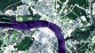 January 2005 saw the start of a research project funded by NSERC I2I and led by GGE's Dr. Yun Zhang to develop breakthrough technology for automatic generation of colour 3D satellite images and dynamic online visualization. In December 2005, a Website for dynamic, multi-scale colour 3D satellite image visualization and online mapping was successfully launched (http://studio2.gge.unb.ca/3DSatelliteImage/). The Website shows 2D and 3D colour satellite images of the Fredericton region at different scales. The technology can be used to generate 3D satellite images covering the globe for worldwide online 3D visualization. The images can be viewed with widely available cardboard 3D glasses such as those distributed recently for the special 3D episode of the NBC television program "Medium".
As early as December 2002, GGE had launched a Website for 2D satellite image online mapping for Fredericton, developed by Dr. Zhang and his Master's student Ms. Pingping Xie, whose Master's research (a 2 MB PDF document) was on online visualization of 3D satellite images. In January 2005 Pingping Xie, M.Sc.E., and Hui Li, M.C.S., joined Dr. Zhang's I2I research project resulting in the developed 3D technology.
2005 Semi-Annual Graduate Seminar
 On Thursday, 8 December 2005, Geodesy and Geomatics Engineering held the Semi-Annual Graduate Seminar. There were 6 graduate students presenting on various topics including ocean mapping, GIS, and GPS. Thank you to Krista Amolins and Ojaswa Sharma who did a fantastic job organizing the seminar and to Meredith Hutchison and Peter McRae who each chaired a session. Thank you as always to Sylvia Whitaker and Tracey Hawco Winchester of the office staff for your continuing hard work and dedication.
Click on the thumbnail image to get a better look, 73 KB.
Click here to look at the paper abstracts. (a 199 KB PDF document)
UNB, IBGE Host Workshop on Geodetic Networks in Brazil
 A workshop on the Integration of the Brazilian Geodetic System into SIRGAS2000 was held 26-30 November at the Brazilian Institute of Geography and Statistics (IBGE), Rio de Janeiro, Brazil. The workshop was attended by the participants in the Working Group 2 Activity within the National Geospatial Framework Project funded by the Canadian International Development Agency (CIDA).
More ...
Faculty of Engineering Awards Evening
 On Thursday, 10 November, the Faculty of Engineering hosted an awards evening at the Delta Fredericton Hotel. Following is a list of GGE students who have won awards this year.
| Frank Bailey | Minto, NB | Purdy MacDonald Scholarship and Bursary |
|---|---|---|
| Nicholas Bardsley | St. John, NB | M. Patrick Gillin Award in Engineering |
| Shawn Benteau | Fredericton, NB | Wheatley Memorial Bursary |
| Ian Church | Fredericton, NB | Brenda Claire Sharpe Memorial Scholarship |
| Justine Clark | Summerside, PEI | Governor Thomas Carleton Scholarship Hamilton-Roberts Entrance Scholarship in Geomatics Engineering |
| Ian Cleland | Deep River, ON | Edwin Jacob Special University Scholarship |
| Alix d'Entremont | Yarmouth, NS | Edwin Jacob Special University Scholarship |
| Ivan Detchev | Vancouver, BC | Brenda Claire Sharpe Memorial Scholarship |
| Robyn Fraser | Winnipeg, MB | Gottfried Konecny Survey Award |
| Erin Grass | Fredericton, NB | L. A. Gale Prize |
| Mark Hatcher | Truro, NS | Wheatley Memorial Bursary |
| Aloysois Ye-Ai Kam | Malaysia | Governor Thomas Carleton Scholarship |
| Clark Langridge | Vulcan, AB | Focus Corporation Ltd. Scholarship |
| George McKessock | Mactaquac, NB | UNB Alumni Merit Award Leica Geosystems Limited Scholarship Brenda Claire Sharpe Memorial Scholarship |
| Brandon Mol | Charlottetown, PEI | Donald MacFayden BScSE Memorial Scholarship |
| Sarah Moore | Charlottetown, PEI | Edwin Jacob Special University Scholarship |
| Rory O'Connell | Toronto, ON | Edwin Jacob Special University Scholarship |
| Brett Richardson | Charlottetown, PEI | Joseph Braithwaite Memorial Scholarship |
| Todd Sabean | Maple Creek, SK | Ward Chipman Founder's Scholarship |
| Ryan Seguin | Sudbury, ON | Brenda Claire Sharpe Memorial Scholarship |
| Alexander Snyder | Fredericton, NB | David Bruce Ritchie Schousboe Memorial Scholarship Alumni Undergraduate Scholarship |
| Matthew Webb | Selkirk, ON | Brenda Claire Sharpe Memorial Scholarship |
Click on the thumbnail image to get a better look, 14 KB.
A New Scholarship for GGE Undergraduate Students
![]() The University of New Brunswick has approved the Association of New Brunswick Land Surveyors Scholarship for $1,000. This scholarship is open to undergraduate students in Geodesy and Geomatics Engineering at the University of New Brunswick who have completed at least two of the four cadastral surveying option courses: GGE5521 Survey Law; GGE5532 Land Economy and Administration; CE5313 Urban Planning; or CE5342 Site Planning. UNB and GGE thank the Association of New Brunswick Land Surveyors for their continuing support of the Department and our undergraduate students.
The University of New Brunswick has approved the Association of New Brunswick Land Surveyors Scholarship for $1,000. This scholarship is open to undergraduate students in Geodesy and Geomatics Engineering at the University of New Brunswick who have completed at least two of the four cadastral surveying option courses: GGE5521 Survey Law; GGE5532 Land Economy and Administration; CE5313 Urban Planning; or CE5342 Site Planning. UNB and GGE thank the Association of New Brunswick Land Surveyors for their continuing support of the Department and our undergraduate students.
Eighteen GGE Undergraduates Make Dean's List
 Eighteen students from Geodesy and Geomatics Engineering have made the Dean's List for 2004-2005. The dean of engineering, David Coleman, announced that the students who qualified for the list attained a sessional grade-point average of at least 3.7 or A- for the academic year. Congratulations go out to the following students:
| Fredericton, NB | Ian Church |
|---|---|
| Erin Grass | |
| Alexander Snyder | |
| Mactaquac, NB | George McKessock |
| Bridgewater, NS | Robert Kingdon |
| Wolfville, NS | Tristan Goulden |
| Yarmouth, NS | Alix d'Entremont |
| Charlottetown, PE | Brett Richardson |
| Deep River, ON | Ian Cleland |
| Selkirk, ON | Matthew Webb |
| Sudbury, ON | Ryan Sequin |
| Brandon, MB | LeMont Edwards |
| Battleford, SK | Regan Rayner |
| Edmonton, AB | Ryan Pals |
| Vulcan, AB | Clark Langridge |
| Surrey, BC | Emily Prokopetz |
| Vancouver, BC | Ivan Detchev |
| Malaysia | Suresh Jeyaverasingam |
Dr. Adam Chrzanowski Coorganizing IAG Symposium
 Dr. Adam Chrzanowski and UNB's Canadian Centre for Geodetic Engineering along with Prof. Heribert Kahmen of the Institute of Geodesy and Geophysics Engineering at the Vienna University of Technology in Austria are organizing a symposium for the International Association of Geodesy. The 3rd IAG Symposium on Geodesy for Geotechnical and Structural Engineering and the 12th FIG Symposium on Deformation Measurements will take place 22-24 May 2006 in Baden, Austria. For more information go to http://info.tuwien.ac.at/ingeo/sc4/baden/index.htm
Mapping the Northwest Passage
Update to UNB Research Vessel to Map the Northwest Passage
 After successfully transiting the Northwest Passage, the CCGS Amundsen steamed between scientific stations in the Amundsen Gulf and Beaufort Sea, eventually reaching the seaward extension of the border between Yukon and Alaska. GGE students Ian Church (undergraduate) and Jonathan Beaudoin (PhD student) were onboard.
More ...
UNB GGE Garners Two Best Paper Awards at ION GNSS 2005
 Two of the papers presented by GGE authors at The Institute of Navigation GNSS 2005 meeting in Long Beach, California, last month won "best paper" awards. The paper "Range-Extended Post-Processing Kinematic (PPK) in a Marine Environment" by Marcelo Santos, Karen Cove, Robert Kingdon, and Dave Wells was selected as the best paper in Session E2, Marine Applications. And the paper "High-Accuracy Point-Positioning with Low-Cost GPS Receivers: How Good Can It Get?" by Tomas Beran, Richard Langley, Sunil Bisnath, and Luis Serrano was selected as the best paper in Session B4, Precise Point Positioning.
Congratulations to the authors on another significant GGE accomplishment!
Run for the Cure Bake Sale: Huge Success
 On 13 September the GGE team for the 2005 CIBC Run for the Cure hosted a bake sale. Tracey and Sylvia (in photo) along with Dominic Blakely, Donna Hammond, and Terry Arsenault put a lot of effort into this fund raiser and it shows. They raised $275.00. Congratulations on a job well done. (Photo: Terry Arsenault, 2005-September-13)
Click on the thumbnail image to get a better look, 37 KB.
GGE's Julie Baglole Helps Ecuador's Indigenous People
 Undergraduate student Julie Baglole spent her summer working in South America with the St. Thomas Human Rights Society's Ecuador Project. She and 11 other Canadians lived and worked in La Esperanza, an indigenous community where people still live in traditional houses made of mud and hay. While there, they planted trees at the top of a mountain approximately 2900 metres high, painted churches, built bleachers in the community centre, built a fence around the community garden, taught English to children from surrounding communities and built a bathroom for a school in a neighbouring community.
Click on the thumbnail image to look at photos provided by Julie, 119 KB.
Click here (a 1.5 MB PDF document) to learn more about the Ecuador Project.
Read the UNB Perspectives article on Julie's experience.
A Welsh Visitor
 Mr. Stephen Ward from the Technology Department of The College Ystrad Mynach in Wales visited the Department between 27 August and 4 September. Steve was here to investigate how education and training in geomatics is carried out and funded in Canada. There is a funding difficulty in the United Kingdom for employers involved in geomatics so any lessons learnt would be fed back to the U.K. Funded by the British Council, Steve visited geomatics companies in Fredericton, local colleges, government and the Association of New Brunswick Land Surveyors.
The picture shows Steve being presented with a memento at the end of his visit. (Photo: Terry Arsenault, 2005-September-1)
Click on the thumbnail image to get a better look, 28 KB.
GGE Well Represented at Cairns Conference
 Eight presentations authored by GGE faculty and students were featured during the Dynamic Planet 2005 Conference. Dynamic Planet 2005 "Monitoring and Understanding a Dynamic Planet with Geodetic and Oceanographic Tools" was in a unique Joint Assembly of International Associations: International Association of Geodesy (IAG), International Association for the Physical Sciences of the Ocean (IAPSO) and International Association for Biological Oceanography (IABO). The conference took place on 22-25 August, in Cairns, Australia.
UNB presentations:
"Accessing the New SIRGAS2000 Reference Frame Through a Modernized Brazilian Active Control Network" by Luiz Paulo Fortes, Sonia Costa, Marco Lima and Marcelo Santos.
"An Analysis of Errors Introduced by the Use of Transformation Grids" by Felipe Nievinski and Marcelo Santos.
"Issues and Impacts of Adopting SIRGAS2000 in Brazil" by Marcelo Santos and Luiz Paulo Fortes.
"Compilation of a Map of Vertical Crustal Movements in Eastern Canada Using Smooth Piecewise Algebraic Approximation" by Azadeh Koohzare, Petr Vaníček and Marcelo Santos.
"An Empirical Stochastic Model for GPS" by Rodrigo Leandro and Marcelo Santos.
"Feeding Neural Networks Models with GPS Observations: A Challenging Task" by Rodrigo Leandro, Carlos Augusto Uchoa Silva and Marcelo Santos.
"Helmert and Rigorous Orthometric Heights" by Marcelo Santos, Petr Vaníček, Artu Ellmann and Robert Kingdon.
"Explicit Formula for the Geoid-Quasigeoid Separation" by Robert Tenzer, Pavel Novák, Philip Moore, Michael Kuhn and Petr Vaníček.
Click on the thumbnail image to get a better look, 37 KB.
Welcome to New Faculty and Support Staff
 In August, we welcomed three new people to the Department.
Dr. Darka Mioc is our new Assistant Professor in Geographical Information Systems. Dr. Mioc comes to us from the University of Calgary where she was also an Assistant Professor in GIS.
Dr. François Anton is our newest Adjunct Professor. Dr. Anton was a Post-doctoral researcher at the Visualisation and Interactive Computing Laboratory, Department of Computer Science, University of Calgary.
Sheri MacPherson is our new secretary. Sheri has been working on various short-term contracts with Joseph Wilby's Law Office, Springhill Construction and most recently Natural Resources Canada. She worked for ADI Limited for a number of years and is a graduate of the Atlantic Business College.
Click on the thumbnail image to get a better look, 37 KB.
GGE a Hit with Shad Valley Students
 On 13 and 14 July, this year's Shad Valley participants worked with volunteers from the Department on GPS and GIS exercises. Shad Valley is a non-profit organization that provides "top students in senior high school to find an edge in the competitive, knowledge-based world of tomorrow." Thanks to volunteers Bessie Liu, Teresa Tang, and Yongdae Gweon, a good time was had by all.
During the GPS exercise, participants used GPS receivers to navigate from one waypoint to another around the campus. They collected scrambled letters at each waypoint, which provided the clue to finding an envelope located in the building closest to the last waypoint. The envelope contained questions about geomatics. They then had to answer all the questions with the winners being the first team to complete the exercise.
The GIS exercise introduced the participants to GIS and how GIS could help them "in real life." They used ESRI's ArcView software to perform some queries and analysis for assessing the impact of construction in downtown Fredericton, and Google Earth which allowed the students to "zoom in" on where they live.
Click on the thumbnail image to see the Shad Valley students and volunteers, 122 KB.
Meredith Hutchison Wins Best Poster Presentation
![]() Congratulations to graduate student Meredith Hutchison who won a Best Poster Presentation at the 2005 Aquaculture Canada Conference in St. John's, Newfoundland in early July. The poster was entitled: "The Potential for Public Participation GIS as a 'Push' Technology for Disseminating Aquaculture Information to Stakeholders." Meredith is working towards her M.Sc.E. under Dr. Sue Nichols.
Congratulations to graduate student Meredith Hutchison who won a Best Poster Presentation at the 2005 Aquaculture Canada Conference in St. John's, Newfoundland in early July. The poster was entitled: "The Potential for Public Participation GIS as a 'Push' Technology for Disseminating Aquaculture Information to Stakeholders." Meredith is working towards her M.Sc.E. under Dr. Sue Nichols.
Dr. Santos and Family Become Canadians
![]() On June 23, Dr. Marcelo Santos, his wife Denise Ferreira and their son Thales became citizens of Canada. Dr. Santos has been a faculty member in the Department since July 2000 when he and his family moved to Fredericton from Rio de Janeiro.
On June 23, Dr. Marcelo Santos, his wife Denise Ferreira and their son Thales became citizens of Canada. Dr. Santos has been a faculty member in the Department since July 2000 when he and his family moved to Fredericton from Rio de Janeiro.
When asked what it meant to him to be a citizen of Canada, Marcelo said:
"Well, being a Canadian citizen means so much that it is difficult to decipher it in one short sentence. But, I think that among everything, it means to be sensitive to your neighbour, careful with the environment and both demanding for and striving for higher standards."
Click on the thumbnail image to get a better look, 31 KB. (Photo: Petr Vaníček, 2005-June-23)
UNB Research Vessel to Map the Northwest Passage
![]() As part of its commitment to the ArcticNet National Centres of Excellence project, UNB's Ocean Mapping Group is sending their research mapping vessel, the CSL Heron, to the Arctic for the 2005 ArcticNet field season. Outfitted with a wide array of acoustic mapping sensors, the vessel will take its place onboard the CCGS Amundsen, a Coast Guard icebreaker dedicated to supporting ArcticNet scientific operations in the Canadian arctic.
As part of its commitment to the ArcticNet National Centres of Excellence project, UNB's Ocean Mapping Group is sending their research mapping vessel, the CSL Heron, to the Arctic for the 2005 ArcticNet field season. Outfitted with a wide array of acoustic mapping sensors, the vessel will take its place onboard the CCGS Amundsen, a Coast Guard icebreaker dedicated to supporting ArcticNet scientific operations in the Canadian arctic.
The CCGS Amundsen has similar acoustic instrumentation and the two vessels will perform parallel mapping operations in various locations throughout the Canadian arctic archipelago. GGE undergraduate students Steve Brucker and Ian Church will be mapping with the CSL Heron in the shallower waters of the Northwest Passage while the icebreaker performs similar mapping operations in deeper waters. Though this is the first time the CSL Heron will be mapping in the north, the Ocean Mapping Group has been running the acoustic instrumentation onboard the CCGS Amundsen since 2003. Prior to being trucked to Quebec City, the Amundsen's home port, the CSL Heron had been operational for over a month mapping in the Kennebecasis Estuary in New Brunswick and the coastal Bay of Fundy area through a research partnership with the federal Department of Fisheries and Oceans.
For more information about UNB's role in ArcticNet, visit http://omg.unb.ca/Projects/Arctic/ArcticNet/index.html
For more information about the CSL Heron, visit http://omg.unb.ca/Heron/CSL_Heron.html
Update: The Heron was hoisted onto the deck of the Amundsen on 8 July. The Amundsen is scheduled to sail north on 5 August. Click on the thumbnail image to look at photos taken during preparations for the voyage, 104 KB.
Gang Hong Wins PCI Geomatics Award of GeoIntelligence
 Congratulations to Gang Hong, a Ph.D. candidate under the supervision of Professor Yun Zhang, who has won a PCI Geomatics Award of GeoIntelligence. The goal of this award is to encourage and promote excellence in student research by providing students with PCI Geomatics leading edge software and solutions. The award included a Geomatica Prime license and $250.00. The license will be functional as long as the winners remain students. Only three awards were given out in this category. The award ceremony was held on 30 May at the GEOIDE Annual Conference 2005 in Quebec City.
UNB Maps Lake Powell
 In 1963, the Glen Canyon dam was built on the Colorado River just south of the Arizona/Utah border in the southwestern United States. The reservoir slowly filled with water, reaching full pool in the early 1980s and creating the second largest man-made lake in the United States: Lake Powell. Along with water came the characteristic sediment that gives the Colorado river its distinctive light brown colour, making it "too thick to drink, and too thin to plow". In cooperation with Duke University, the U.S. National Park Service, and the U.S. Bureau of Reclamation, Ocean Mapping Group Chair, Dr. John Hughes Clarke, and his research assistant, Jonathan Beaudoin, travelled to Lake Powell in early May to perform a 10-day multibeam sonar survey of the now submerged river channel. The purpose of the survey was to provide a baseline map of the sediment distribution in the hope that future repeat surveys will shed light on the locations and rates of sediment accumulation. This information will be used to improve estimates of the expected useable lifetime of the reservoir before it becomes filled with sediment.
Click on the thumbnail image to look at photos taken during the survey, 56 KB.
For more information about the survey, please visit http://chamcook.omg.unb.ca/powell/
For a Google™ satellite image and map of Lake Powell, visit http://maps.google.com/maps?q=lake+powell&ll=37.376953,-110.861650&sll=35.562500,-108.312746&spn=1.408997,1.958313&sspn=16.031250,28.875765&t=k&hl=en
GGE Student Wins 2005 Geomatics Canada Scholarship
![]() Congratulations to GGE student Erin Grass who has been awarded one of the Geomatics Canada Scholarships for 2005. Funded by Natural Resources Canada and GeoConnections, and administered annually by the Canadian Institute of Geomatics (CIG), this scholarship was created to assist students enrolled in a post-secondary institution in the field of geomatics.
Congratulations to GGE student Erin Grass who has been awarded one of the Geomatics Canada Scholarships for 2005. Funded by Natural Resources Canada and GeoConnections, and administered annually by the Canadian Institute of Geomatics (CIG), this scholarship was created to assist students enrolled in a post-secondary institution in the field of geomatics.
The scholarship program includes four graduate level university scholarships of $2,500, eight undergraduate level university scholarships of $2,000, and eight college/technical institute scholarships of $1,500 which are awarded annually and distributed throughout the geomatics disciplines.
The CIG also presented the scholarship winners with a complimentary one-year student membership, which includes a subscription to Geomatica.
Azadeh Koohzare Wins Best Paper Award
 Congratulations to Azadeh Koohzare, a Ph.D. candidate under the supervision of Professor Marcelo Santos and Professor Emeritus Petr Vaníček, who has won the Best Student Paper Award (Geodesy Section) at the Annual Meeting of the Canadian Geophysical Union held in Banff, Alberta, 8-12 May. The title of the paper is Compilation of a map of vertical crustal movements in Eastern Canada using spline polynomials. The cash prize of $500.00 is a donation from the Geodetic Survey Division of Natural Resources Canada. Our congratulations go out to Azadeh!
Former GGE Advisory Committee Chair to be Appointed to the Order of Canada
![]() Mike Eaton, scientist emeritus of the Canadian Hydrographic Service and a former chair of GGE's Advisory Committee is to be inducted into the Order of Canada at a ceremony in Ottawa on 10 June.
Mike Eaton, scientist emeritus of the Canadian Hydrographic Service and a former chair of GGE's Advisory Committee is to be inducted into the Order of Canada at a ceremony in Ottawa on 10 June.
The citation to be read at his investiture is as follows:
"With vision, innovation and ingenuity, Michael Eaton has made outstanding contributions to the advancement of hydrography in Canada. Scientist Emeritus with the Canadian Hydrographic Service, he developed techniques to accurately map frozen bodies of water and combined various positioning systems to more precisely survey ocean waters. Renowned nationally and internationally as the "father of the electronic chart," he envisaged a computerized version of the traditional marine chart. This electronic chart has become a common navigation tool for many shipping and recreational vessels, contributing to greater marine safety around the world."
UNB Authors to Receive 2004 Intermap Award
 Congratulations to GGE's Peter Dare and former GGE student Wade MacNutt who will receive the 2004 Intermap Award at the Canadian Institute of Geomatics (CIG) conference in June. The award is presented for the best paper appearing in the CIG's publication Geomatica during the year of the award as judged by Intermap. Prof. Dare and Mr. MacNutt share the award with their co-author, UNB research associate, Dr. Shawn Dalton. The winning paper is entitled "Use of a Digital Terrain Model as a Means of Urban Watershed Delineation in Fredericton, New Brunswick" and was published in Geomatica, Vol. 58, No. 2, pp. 107-119.
The Intermap Award is presented by Intermap Technologies to stimulate authorship in Geomatica in all fields of the geomatics sciences. Papers are judged for originality, practical value, conciseness, clarity of expression and general interest. The amount of the award is $300.
NSERC Discovery Grants Success
 It is with pleasure that the department announces that Dr. Don Kim, and Profs. Hughes Clarke and Dare have been awarded Natural Sciences and Engineering Research Council of Canada (NSERC) Discovery Grants. These NSERC grants are especially important as they are often the key to getting funding from additional sources.
The success of these researchers enables the department to proudly say that every one of our professors and research associates has an NSERC Discovery Grant.
Dr. Kim should be especially congratulated as this was his first attempt at Discovery Grant funding.
Dr. Kim's grant project is entitled "Development of Remote-Controlled Autonomous RTK System Using Global Navigation Satellite Systems," while Prof. Hughes Clarke's is "Improved Mapping and Monitoring Techniques to Resolve Seabed Change and Associated Coupling with the Water Column" and Prof. Dare's is "Creation of High-quality Global Navigation Satellite System Investigative Methods."
Read the associated UNB news release.
Emeritus Prof. Petr Vaníček Granted Humboldt Award Follow-on
 The Alexander von Humboldt Foundation has awarded GGE Emeritus Prof. Petr Vaníček a "re-invitation" to spend a month in Germany to carry out collaborative research with a colleague at the University of Stuttgart. Prof. Vaníček was originally honoured with a Humboldt Senior Distinguished Scientist Award in 1989 and he spent half a year with Prof. Erik Grafarend at the University of Stuttgart working on problems related to Earth's gravity field. Prof. Vaníček was only the second Canadian to receive the prestigious award.
In May, Prof. Vaníček returns to Stuttgart where he will work with Prof. Grafarend, now an emeritus professor in the Institute of Geodesy, on invariants of the strain matrix in two and three dimensions.
Employment Opportunity - We're Looking for a Geomatics Technologist
 The Department of Geodesy and Geomatics Engineering (GGE) at the University of New Brunswick (UNB) (Fredericton Campus) invites applications for a Geomatics Technologist.
Willis Roberts to Receive Doctor of Science Honoris Causa
![]() Congratulations to Willis Roberts, the "Father of Geomatics in Atlantic Canada" who will receive a doctor of science honoris causa from the University of New Brunswick during its 176th Encaenia on the afternoon of 19 May, 2005. Mr. Roberts is a charter member of the Association of New Brunswick Land Surveyors as well as the Association's first president.
Congratulations to Willis Roberts, the "Father of Geomatics in Atlantic Canada" who will receive a doctor of science honoris causa from the University of New Brunswick during its 176th Encaenia on the afternoon of 19 May, 2005. Mr. Roberts is a charter member of the Association of New Brunswick Land Surveyors as well as the Association's first president.
In 1959, on a train bound for Ottawa, Canada, Willis Roberts (then Director of Surveys for New Brunswick), Bill Hilborn (then professor of photogrammetry in the Faculty of Forestry), Ira Beattie (then Head, Civil Engineering Department), and Gottfried Konecny (then Assistant Professor, Civil Engineering), had a dream of a surveying engineering department at UNB. In 1960, their dream was brought to fruition with the help of Jim Dineen (then Dean of Engineering), Colin B. McKay (then President of UNB), and Archie McLaughlin (then a surveyor with the New Brunswick Lands Branch). The Department was renamed the Department of Geodesy and Geomatics Engineering in 1994.
Two decades before the information highway became a buzzword, Willis Roberts had a vision of a computer-based system for the management of all land-related data. To make the vision a reality, he initiated discussions that led to the establishment of the Atlantic Provinces Surveying and Mapping Program in 1968. A UNB forestry graduate, Mr. Roberts served as its technical director, then as executive director of its successor, the Land Registration and Information Service. In 1979, he was named president of LRIS International, a Council of Maritime Premiers' agency that marketed surveying, mapping and land information services. In 1983, he received the Massey Medal from the Royal Canadian Geographical Society for outstanding personal achievement in the description of the geography of Canada.
Click on the thumbnail image to get a better look, 12 KB.
Read the associated UNB news release.
Updates: Photos taken at the ceremony and at a reception following the ceremony.
Dr. Yun Zhang Named UNB University Research Scholar
 Congratulations to Dr. Yun Zhang who has been named a UNB University Research Scholar for a two-year period beginning 1 July, 2005. The award honours UNB researchers who have demonstrated a consistently high level of scholarship, and whose research is, or has the potential to be, of international stature.
Click on the thumbnail image to get a better look at Dr. Zhang being presented the award, 32 KB.
2005 Student Technical Conference
 The 2005 Student Technical Conference was held on March 22, 23, and 24. There were 21 undergraduate and 11 graduate presenters. During the conference, there were two paper competitions: one for graduate students and one for undergraduate students.
More ...
UNBF Researchers Study Space Weather with Super Computer
 When it comes to space weather, it's not just about whether it's raining or cloudy.
Not even close.
"Space weather affects radio communications and navigation systems such as the Global Positioning System (GPS) so it's not a case of what you see is what you get," said Richard Langley, a geodesy and geomatics engineering professor at UNBF. "Space weather includes a variety of phenomena taking place in the Earth's upper atmosphere. Conditions on the sun and in the solar wind, the magnetosphere and the ionosphere can affect our daily lives through the effects they have on satellites, communications, navigation and power systems."
With that in mind, Dr. Langley and Hyunho Rho, a PhD candidate in UNBF's GGE department, have developed a new technique for studying space weather using GPS.
More ...
Commemorating the First Use of the Meridian Pillar Placed by William Brydone Jack
 In recognition of the efforts by former UNB President Dr. William Brydone Jack to improve the quality of surveying in New Brunswick, the following note has been placed as a plaque near the meridian pillar.
"IN 1874, THIS STONE PILLAR WAS PLACED BY PROF. WILLIAM BRYDONE JACK ON THE MERIDIAN THROUGH THE OBSERVATORY TO ENABLE HIS CALIBRATION OF LAND SURVEYORS' COMPASSES IN AN EFFORT TO IMPROVE THE SURVEYS OF LAND IN NEW BRUNSWICK"
As part of the celebration of its 50th anniversary of incorporation, the Association of New Brunswick Land Surveyors collaborated with the Department of Geodesy & Geomatics Engineering at UNB to refurbish the immediate vicinity of the pillar and to place the plaque.
A commemoration ceremony was held on Thursday, 17 February with local members of ANBLS, UNB faculty and librarians, and students in attendance. During the ceremony, it was noted that this month marks the 150th Anniversary of the first determinations of precise longitude in Canada using the electric telegraph. The measurements were made by Brydone Jack and his colleague, J. B. Toldervy.
Click on the thumbnail image to get a look at some of the people attending the ceremony, 39 KB.
GGE Student Awarded Aquaculture Association of Canada Scholarship
 Each year, the Aquaculture Association of Canada (AAC) awards 6 scholarships worth $1,000 each for students enrolled in post-secondary studies in an aquaculture-related program. This year, Meredith Hutchison, a GGE M.Sc.E. student, is a recipient of one of these scholarships for her continuing research into aquaculture policy and information management in Canada.
For more information about this scholarship see http://www.aquacultureassociation.ca/Scholarship/scholarship.html
Congratulations Meredith.
Dr. Yun Zhang Wins 2005 Talbert Abrams Grand Award
![]() Congratulations to Dr. Yun Zhang who has won, with his co-authors C. Vincent Tao and J. Bryan Mercer, the 2005 Talbert Abrams Grand Award for their paper entitled, "An Initial Study on Automatic Reconstruction of Ground DEMs from Airborne IfSAR DSMs." Photogrammetric Engineering & Remote Sensing (70-4, pp. 427-438). The award consists of a plaque and a cash award of $3,000 to be presented at the American Society for Photogrammetry and Remote Sensing 2005 Annual Conference in Baltimore, Maryland on 9 March.
Congratulations to Dr. Yun Zhang who has won, with his co-authors C. Vincent Tao and J. Bryan Mercer, the 2005 Talbert Abrams Grand Award for their paper entitled, "An Initial Study on Automatic Reconstruction of Ground DEMs from Airborne IfSAR DSMs." Photogrammetric Engineering & Remote Sensing (70-4, pp. 427-438). The award consists of a plaque and a cash award of $3,000 to be presented at the American Society for Photogrammetry and Remote Sensing 2005 Annual Conference in Baltimore, Maryland on 9 March.
Click on the thumbnail image to learn more about the award, 69 KB.
UNB - Brazilian Institute Partnership on Land Project
 After two years of planning, January 18th marked the official launch of the $7.3 million project between the University of New Brunswick and the Instituto Brasileiro de Geografia e Estatística (IBGE) in Brazil. Dr. Marcelo Santos, professor in Geodesy and Geomatics Engineering is the project team leader with more than thirty Brazilian partners involved as well as Natural Resources Canada, Service New Brunswick, UNB's Centre for Property Studies, WaterMark Industries, Trainor Surveys, and Optex Inc.
Click on the thumbnail image to get a better look at the launch speakers, 33 KB.
Read the associated UNB news release.
Update: photo taken at the launch of the National Geospatial Framework Project in Brazil.
GGE Student Leads UNB Fund-Raising for Asian Tsunami Relief
 University of New Brunswick students lead by GGE student Kugan Vinayagasothy raised $10,353.50 for victims of the tsunami. Kugan and friends Thatchen and Manoj worked tirelessly along with many volunteers to be able to present the cheque to Pat Burgess of the Red Cross.
Click on the thumbnail image to get a better look at some of the people involved, 35 KB.