

2019 ·
2018 ·
2017 ·
2016 ·
2015 ·
2014 ·
2013 ·
2012 ·
2011 ·
2010 ·
2009 ·
2008 ·
2007
2006 ·
2005 ·
2004 ·
2003 ·
2002 ·
2001 ·
2000 ·
1999 ·
1998 ·
1997 ·
1996 ·
1995
 · What is RSS?
GGE News - 2016
- GGE Graduates Meet at Spatial Data Conference in Taipei
- Prof. Zhang's Work Featured on Front Cover of Photogrammetric Engineering & Remote Sensing
- UNB's Department of Geodesy and Geomatics Engineering Welcomes Dr. Ian Church
- Fall Graduate Seminar and Student Technical Conference
- First IAG Positioning and Applications Symposium
- Scientific Congress of CMOS and CGU Back to Fredericton After 37 Years - and GGE Organized It!
- Canada Foundation for Innovation Visits GGE's Advanced Geomatics Image Processing Lab
- GGE Graduate Student Wins American Fellowship Award
- New EarthView3D Technology Developed by GGE Professor Yun Zhang
GGE Graduates Meet at Spatial Data Conference in Taipei
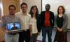
![]() Halfway around the world from UNB, GGE graduates Dr. T.Y (Peter) Shih, Dr. Dozie Ezigbalike and GGE faculty member Dr. David Coleman caught up with each other last month at the GSDI (Global Spatial Data Infrastructure) 15 Conference held in Taipei, Taiwan. Dr. Shih is currently a professor in the Department of Civil Engineering at the National Chiao Tung University in Taiwan. Dr. Ezigbalike (remembered by the name "Innocent" in his days at UNB) serves as chief of the Data Technology Section at the United Nations Economic Commission for Africa. Both Dr. Shih and Ezigbalike were members of the conference program committee. In his role as outgoing president of the Global Spatial Data Infrastructure Association, Dr. Coleman acted as the conference co-chair.
Halfway around the world from UNB, GGE graduates Dr. T.Y (Peter) Shih, Dr. Dozie Ezigbalike and GGE faculty member Dr. David Coleman caught up with each other last month at the GSDI (Global Spatial Data Infrastructure) 15 Conference held in Taipei, Taiwan. Dr. Shih is currently a professor in the Department of Civil Engineering at the National Chiao Tung University in Taiwan. Dr. Ezigbalike (remembered by the name "Innocent" in his days at UNB) serves as chief of the Data Technology Section at the United Nations Economic Commission for Africa. Both Dr. Shih and Ezigbalike were members of the conference program committee. In his role as outgoing president of the Global Spatial Data Infrastructure Association, Dr. Coleman acted as the conference co-chair.
Further information on the GSDI 15 Conference and its program may be found at: http://gsdiassociation.org/index.php/homepage/gsdi-15-world-conference.html
Click on the thumbnail to view the GGE graduates attending the conference.
Prof. Zhang's Work Featured on Front Cover of Photogrammetric Engineering & Remote Sensing
![]() The image on the front cover of the October 2016 issue of Photogrammetric Engineering & Remote Sensing, the journal of the American Society for Photogrammetry and Remote Sensing, is a mosaic of the original and pansharpened WorldView-2 satellite imagery, covering a portion of the campus of Peking University. The software used to produce the pansharpened image uses a technique based on the UNB Pansharp algorithm developed by Dr. Yun Zhang in the Department of Geodesy and Geomatics Engineering at the University of New Brunswick. The UNB Pansharp algorithm has been used by DigitalGlobe Inc. to pansharpen its satellite images in a fully automated fashion since 2003.
The image on the front cover of the October 2016 issue of Photogrammetric Engineering & Remote Sensing, the journal of the American Society for Photogrammetry and Remote Sensing, is a mosaic of the original and pansharpened WorldView-2 satellite imagery, covering a portion of the campus of Peking University. The software used to produce the pansharpened image uses a technique based on the UNB Pansharp algorithm developed by Dr. Yun Zhang in the Department of Geodesy and Geomatics Engineering at the University of New Brunswick. The UNB Pansharp algorithm has been used by DigitalGlobe Inc. to pansharpen its satellite images in a fully automated fashion since 2003.
Pansharpening is one of the crucial technologies in remote sensing. It fuses a high resolution panchromatic (pan or black and white -- B/W) image into a low resolution multispectral (MS or colour) image to produce a high resolution colour image. Due to the physical limitation of optical sensors, it is difficult to build a high resolution MS sensor without degrading the signal-to-noise ratio (SNR). Because high SNR is important for remote sensing applications, most modern satellites use a high SNR, low-resolution MS sensor and a high SNR, high-resolution pan sensor to collect images of the Earth's surface. Therefore, the pansharpening technique plays a crucial role in producing high SNR, high resolution colour images.
In an associated highlight article published in the same October 2016 issue of PE&RS, Dr. Zhang and his team confirmed that the SNR of a well-pansharpened high resolution colour image is significantly higher than that of a high resolution colour image directly collected by a high resolution colour sensor. This research outcome was achieved through a multi-disciplinary, multi-institution, and academia-industry collaboration:
- Multi-disciplinary: involving the subject areas of geomatics, optoelectronics, digital imaging, computer vision, and human vision.
- Multi-institution: involving researchers from UNB, MIT (Massachusetts Institute of Technology), Peking University, and INO (National Optics Institute of Canada).
- Academia-industry collaboration: The industry supporters include DigitalGlobe, SenseSharp, PHOTONIS, and i2 innovation.
Click on the thumbnail to view the cover image.
UNB's Department of Geodesy and Geomatics Engineering Welcomes Dr. Ian Church
 Dr. Ian Church joins the department as our new assistant professor in ocean mapping. Dr. Church was born right here in Fredericton, N.B. He completed his higher education at the University of New Brunswick, first with a bachelor's degree in geomatics engineering, and later with M.Sc.E. and Ph.D. degrees in ocean mapping while working under the supervision of Prof. John Hughes Clarke.
Dr. Church specializes in ocean mapping using acoustics. His current primary research interests are in integrating hydrodynamic numerical modelling with ocean mapping, marine habitat mapping, acoustic water column interpretation, and evaluating autonomous mapping platforms. The principal goals of his research are to better understand the marine environment using acoustics and to minimize uncertainty in ocean mapping products.
Between 2005 and 2013, Dr. Church was involved with operating and managing the multibeam sonar system on board the coast guard ship Amundsen, travelling throughout the Canadian Arctic. After spending eight summers in the Arctic and finishing his Ph.D., he moved to the Stennis Space Center at the University of Southern Mississippi on the coast of the Gulf of Mexico. There, he was part of the Hydrographic Science Research Center in the Department of Marine Science. In June 2016, he returned to UNB to take up his appointment in the Department of Geodesy and Geomatics Engineering and assume the leadership role in the Ocean Mapping Group.
Welcome aboard, Ian.
Click on the thumbnail to get a better look.
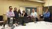
Fall Graduate Seminar and Student Technical Conference
 The GGE Fall 2016 Graduate Seminar and Student Technical Conference was held on Tuesday, 15 November. The well-attended activity showcased the work of four Ph.D. and two M.Sc.E. students making presentations of their selected topics previously submitted in formal papers. Through this event, GGE celebrated the 2016 GIS Day. Download the seminar agenda and presentation abstracts by clicking here.
Click on the thumbnail to look at a photo of some of those involved with the conference.
First IAG Positioning and Applications Symposium
 Commission 4, "Positioning and Applications", of the International Association of Geodesy (IAG) held its very first symposium. It took place in Wroclaw, Poland, from 4 to 7 September 2016. The venue was the Didactic and Scientific Center of the Faculty of Environmental Engineering and Geodesy, at Grunwaldzki Square 24a.
A total of 67 geodesists participated in the event, with the presentation of 58 scientific contributions including 40 orals and 18 posters. Some of the presentation slides and posters are available via the online programme. During the event, several entities of Commission 4 held splinter meetings.
The scientific committee was composed of the members of the Commission 4 executive, listed here.
The Local Organizing Committee, spearheaded by Tomasz Hadas, Krzysztof Sosnica, Anna Krypiak-Gregorczyk and Jacek Paziewski, did a tremendous job, which deserved the accolades of all participants.
The symposium covered the areas of interest of Commission 4, which are by themselves broad in nature. These areas are divided into 4 sub-commissions (SCs). SC 1 deals with emerging positioning technologies including, for example, indoor positioning, UAV positioning and navigation, smartphone positioning and navigation, and ubiquitous positioning. SC 2 is concerned with applications from mapping to monitoring of deformations including multi-sensor systems and laser scanning. Atmospheric remote sensing is the focal point of SC 3 including the ionosphere, neutral-atmosphere, radio occultation, reflectometry, radio occultation, space weather and coupling. And, finally, SC 4, which is dedicated to multi-constellation GNSS methods and technologies and their novel applications.
Click on the thumbnail to get a better look.
Scientific Congress of CMOS and CGU Back to Fredericton After 37 Years - and GGE Organized It!
 After 37 years, Fredericton hosted a Canadian Geophysical Union (CGU) Scientific Meeting. In 1979, Prof. Petr Vaníček spearheaded the event. In 2016, Prof. Marcelo Santos had that honour.
The event this year was a Joint Scientific Congress involving CMOS and CGU. CMOS, the Canadian Meteorological and Oceanographic Society gathered in Fredericton for the last time in 1993. The Joint Congress took place at the Fredericton Convention Centre, from 29 May to 2 June.
This 2016 Joint Congress was organized by a Local Arrangements Committee chaired by Prof. William Ward (UNB, Physics) and Prof. Marcelo Santos, with members from several other local institutions, such as Environment Canada, and tens of volunteers. The Science Committee was led by Paul Yang from Environment Canada.
The event was attended by a total of 550 registered participants, from Canada and the U.S.A., U.K., Brazil, Switzerland, Norway, China, South Korea, Australia and New Zealand. There were 58 science sessions, 6 special sessions, 4 plenary sessions and 1 general public lecture. Also, a total of 13 exhibitors participated in the event. A total of 469 contributions were presented with 355 delivered as oral and 114 as poster.
As is the tradition, both societies held their individual awards banquets simultaneously and in different venues (Fredericton Convention Centre and The Crown Plaza). A number of social and student events took place during the week.
More detailed information can be obtained in the congress Program Book. A collection of pictures can be found here.
Click on the thumbnail to look at photos taken during the meeting.
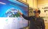
Canada Foundation for Innovation Visits GGE's Advanced Geomatics Image Processing Lab
 On 30 March 2016, representatives of the Canada Foundation for Innovation (CFI) visited the Canada Research Chairs lab in Advanced Geomatics Image Processing (CRC-AGIP) led by Dr. Yun Zhang.
During the visit, Dr. Zhang thanked the CFI for the funding support to purchase state-of-the-art equipment for the lab. Dr. Zhang also introduced the research activities and research achievements of CRC-AGIP. With the CFI-funded equipment, Dr. Zhang's lab has already developed several internationally leading and commercialized technologies, such as image fusion and automated pan-sharpening to improve the resolution of colour satellite imagery.
And now, the lab is in the process of developing additional new technologies including the online 3D mapping system EarthView3D (www.EarthView3D.net). EarthView3D provides online visualization of 3D information about the Earth, which is generated from satellite images, aerial photographs, LiDAR images, bathymetric data (ocean depths), and vector maps of roads, trails, and boundaries.
Click on the thumbnail to look at photos taken during the visit.
GGE Graduate Student Wins American Fellowship Award
 Ryan White, a Ph.D. student working with Prof. Richard Langley in the Department of Geodesy and Geomatics Engineering, has won the American Association for Geodetic Surveying (AAGS) 2015 Graduate Fellowship Award.
Each year, the U.S. National Society of Professional Surveyors Foundation, with the generous support of individuals, companies, and organizations, awards a number of scholarships to encourage and support college and university education in the geospatial sciences.
The highly competitive $2,000 AAGS award is presented to a student enrolled in a graduate program in geodetic surveying or geodesy, preferentially with at least two years of employment experience in the surveying profession. Before coming to UNB, Mr. White worked for several years as a crew chief for his parents' civil engineering and land surveying company.
Click on the thumbnail to get a better look.
New EarthView3D Technology Developed by GGE Professor Yun Zhang
 University of New Brunswick researcher, Yun Zhang, is no stranger to Google Maps. In 2000, he participated in a Street View project led by YC Lee that resulted in Google Street View. Now he's invented what he hopes will be the next generation of Google Maps called EarthView3D (see: http://www.earthview3d.net).
Dr. Zhang is [the] Canada Research Chair in Advanced Geomatics Image Processing in UNB's faculty of engineering. He says there are many benefits to 3D maps and he's hoping to see 3D technology become more mainstream in the coming years.
"Using our EarthView3D technology, civil engineers can more-easily foresee where future roads should be built, the military will be better equipped to go into battle, fire fighters and search and rescue crews will have more insight before beginning their missions, and school students will learn natural geography more effectively," said Dr. Zhang. "These are just a few examples of what this technology could be used for."
Read more at the UNB Newsroom: http://blogs.unb.ca/newsroom/2016/01/26/new-earthview3d-technology-developed-at-unb/
Click on the thumbnail to get a better look.