

2019 ·
2018 ·
2017 ·
2016 ·
2015 ·
2014 ·
2013 ·
2012 ·
2011 ·
2010 ·
2009 ·
2008 ·
2007
2006 ·
2005 ·
2004 ·
2003 ·
2002 ·
2001 ·
2000 ·
1999 ·
1998 ·
1997 ·
1996 ·
1995
 · What is RSS?
GGE News - 2011
- GGE Researchers Among First to Track New Galileo SatNav Signals
- New Entrance Scholarship for GGE Students
- Fall 2011 Semi-Annual Graduate Student Seminar
- Ocean Mapping Group Concludes Another Successful Research Season on CCGS Amundsen
- Anna Szostak-Chrzanowski Delivers Wrocław University of Technology Opening Address
- Ocean Mapping Group Completes First Phase of 2011 Operations in the Canadian Arctic
- GGE Team Develops Hydrological Models for Base Gagetown
- GGE Ph.D. Student Wins Best Paper Award at International Navigation Conference
- Richard Langley Appointed to U.S. National Research Council Committee
- GGE Welcomes Dr. Emmanuel Stefanakis
- Marcelo Santos Appointed Fellow of the International Association of Geodesy
- Robin Steeves Appointed GGE Honorary Research Associate
- UNB Appoints Two GGE Adjunct Professors
- 2011 Student Technical Conference
- Yun Zhang and Team Win Breakthru Competition
- GGE's SceneSharp Technology a Finalist in Breakthru Business Plan Competition
- GPS Shows Large Position Shifts Due to Japanese Earthquake
- Yun Zhang Recognized at Celebration
- John Hughes Clarke Awarded the Michael J. Keen Medal
- Yun Zhang Presents Breakthrough Technologies for Image Processing
- GGE Members Featured in First Issue of New Geodesy Journal
- William Brydone Jack, UNB's First Teacher of Surveying, Honoured
GGE Researchers Among First to Track New Galileo SatNav Signals
 An advanced satellite-tracking receiver operated by the Department of Geodesy and Geomatics Engineering on the University of New Brunswick Fredericton campus was one of the first in the world to acquire and track the signals from a recently launched Galileo navigation satellite.
Galileo is Europe's global navigation satellite system (GNSS) now under development and scheduled for initial operation by 2015 or so. The first two Galileo In-Orbit Validation (IOV) satellites were launched on 21 October 2011 from the European Space Agency's Spaceport in Kourou, French Guiana.
On Saturday, 10 December, at about 06:00 UTC, one of the IOV satellites (PFM or ProtoFlight Model) started transmitting navigation signals on the L1/E1 frequency using the E11 ranging code. These signals were acquired by UNB's receiver in the Cooperative Network for GIOVE Observation (CONGO) that was established in 2008 by the German Space Operations Center and the German Federal Agency for Cartography and Geodesy as an early test bed for experimentation with new GNSS signals. Data from the receiver is streamed in real time from UNB to the CONGO data processing centre in Munich over the Internet.
The signals transmitted by the Galileo satellites will offer improved performance compared to the conventional signals transmitted by the GPS satellites.
The following figure shows signal strengths (known as C/N0 values in units of dB-Hz) of the PFM 1-second data collected by the UNB CONGO station on 10 December. The time axis runs for 24 hours starting at 01:00 UTC. The receiver is a Delta-G2T manufactured by Javad GNSS.
New Entrance Scholarship for GGE Students
 The Department of Geodesy and Geomatics Engineering is pleased to announce the creation of the Simon Newby Geomatics Scholarship. It will be awarded to a student beginning the Bachelor of Science in Engineering (Geodesy and Geomatics) degree program directly from high school. Selection will be based primarily upon the demonstration of leadership/entrepreneurial qualities, and/or demonstrable special needs, and/or demonstrable financial need. In all instances, excellent academic performance is a requirement. Further information is available here: http://www.unb.ca/scholarships/highschool.html.
The scholarship was approved by the Fredericton Senate at its meeting on 29 November 2011.
This scholarship has been donated by UNB alumnus, Simon Newby, who obtained his M.Sc.E. degree in the department in 1992 and who has had a very successful career in the geomatics world.
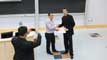
Fall 2011 Semi-Annual Graduate Student Seminar
 On Tuesday 29 November 2011, the Department of Geodesy and Geomatics Engineering held its Semi-Annual Fall Graduate Student Seminar. The conference highlighted some of the most current research activities in the Department, and displayed the continued hard work and ingenuity that has come to be expected of our graduate students.
The conference was a half-day session covering topics in the fields of remote sensing, hydrography, and land management studies. Two sessions were held and chaired by Matthew McAdam (conference organizer) and Travis Hamilton. Some examples of the topics presented in each of the subject areas include:
Remote Sensing:
- Moving Vehicle Extraction from One-Pass WordView-2 Satellite Imagery
- presented by: Rakesh Kumar Mishra
Hydrography:
- Mid-Water Target Detection using Multibeam Water Column
- presented by: Carlos Rubrio Marques
Land Management Studies:
- Legal Liability Concerns Surrounding Volunteered Geographic Information
- presented by: Andriy Rak
For a complete schedule of events, please follow this link.
At the end of the presentations, all attendees gathered for refreshments where ensuing discussions allowed all to garner a greater appreciation of the subject matters at hand.
The conference demonstrated the commitment of the faculty and students in their desire to foster the exchange of ideas in such an open and friendly environment.
A very special thanks to all who participated and assisted in making this a successful endeavour:
- All Presenters
- Matthew McAdam - Organizer/Session Chair
- Travis Hamilton - Session Chair
- Evans Ralston/Norman Chai - Session Timers
- Sylvia Whitaker - Overseer
Click on the thumbnail image to get a better look at some of the participants. This story was contributed by Matthew McAdam.
Ocean Mapping Group Concludes Another Successful Research Season on CCGS Amundsen
 The Department of Geodesy and Geomatics Engineering's Ocean Mapping Group (OMG) completed three more legs of its work in the Arctic before the Canadian Coast Guard Ship Amundsen returned to Quebec City on October 30, 2011, culminating in another very successful season of ocean research for the group.
GGE students Travis Hamilton and Brad Eisan spent the first six weeks of Amundsen's 2011 operations on the vessel as previously reported. They were relieved by OMG research assistants Ian Church and James Muggah, and graduate students Carlos Rubio Marques and Rodrigo Carvalho on August 26 at Sachs Harbour, NWT, to begin work on the next leg of the expedition. The primary goal of this leg was to broaden Canada's understanding of the Beaufort continental slope with a massive bathymetric survey, a series of piston cores, and deployment and retrieval of seabed mooring instrumentation. The bathymetric survey was the final stage of a three-year project to investigate natural seabed geo-hazards in the area.
Several major oil and gas companies have expressed interest in drilling within the Canadian Beaufort Sea, but before drilling can commence a thorough investigation must be undertaken to ensure that drilling in such an environment could be done safely. One major component to this review is to assess whether any natural features on the seabed could damage a pipeline, seabed engineering structures, drill platform or interfere with any other related activity. Examples of potential geo-hazards in the area include ice keel scours, mud volcanoes, and submarine landslides.
The role of the Ocean Mapping Group was to acquire and process the acoustic multibeam and sub-bottom data. The multibeam echo sounder data provided a complete 3D model of the seabed morphology while the sub-bottom data gave insight into the sub-surface seabed structure.
On September 7, after a successful seabed survey campaign, Ian Church, Carlos Rubrio Marques, and Rodrigo Carvalho left the Amundsen in Sachs Harbour. James Muggah stayed aboard to ensure a smooth handover for the next leg and to continue survey operations with OMG researchers Doug Cartwright and Pim Kuus and graduate student Christine Legere.
The main focus of the OMG group's work on the next leg of the expedition was seabed mapping along the Beaufort Shelf with the Amundsen. Besides the Amundsen, they also had the opportunity to use a barge for mapping operations. The Amundsen is equipped with a ~30-ft barge, which is normally used by the Coast Guard to transport passengers or goods to and from shore in shallow waters. Earlier in the summer, OMG had outfitted the barge with an EM3002 multibeam sonar and auxiliary instruments. The barge not only provided the opportunity to run some site-specific surveys while the Amundsen operations took place, but thanks to the EM3002, higher resolution data could be acquired.
The Beaufort continental shelf is dotted with dome-shaped mounds. These features have been coined pingo-like-features (PL's) because of their morphological resemblance with pingos found on shore. Pingos are ice-cored hills and are quite common in the western Arctic landscape. Despite their common dome shape, geologists are uncertain if PLFs are really pingos; what they really are is unclear. Some PLFs appear to be venting gas or extruding fluids or mud. This activity is particularity interesting for geologists as it can be a source of hydrocarbons. In order to understand the processes involved, the barge was used to find the PLFs and map them in three dimensions.
On September 22, Pim Kuuus and James Muggah departed the Amundsen, leaving Doug Cartwright and Christine Legere to carry on with science activities for the remaining two weeks of the leg. During this next period, the priority was taken away from mapping and put towards other science activities, including identification and retrieval of seabed mooring installations and marine mammal surveys.
This leg of the journey also included the “Schools on Board” program (http://www.arcticnet.ulaval.ca/sb/index.php) that provides Canadian high school students with the opportunity to experience science sampling and research activities first hand onboard the icebreaker. Doug Cartwright provided a well-received presentation on acoustics and seabed mapping.
On October 4, Doug Cartwright and Christine Legere left the Amundsen in Kugluktuk, Nunavut, after welcoming OMG researcher Steve Brucker and graduate student Danar Guruh Pratomo aboard. The next leg of the expedition, lasting the better part of a month, took the Amundsen to Cambridge Bay, M'Clintock Channel, Viscount Melville Sound, Resolute, Thule (Greenland), Clyde River, Frobisher Bay, and finally back to Quebec City. Seabed mapping, in addition to many other scientific activities, was carried out during most of the leg.
The multibeam sonar system aboard the Amundsen is never turned off. It logs data any time the ship moves through the water, and sometimes even when it's stationary. Due to this constant state of readiness, OMG personnel manning the sonar can take advantage of small breaks in the schedule. The first of these opportunistic surveys occurred while they were in the vicinity of Cambridge Bay. The ship headed out to the shipping lane that winds through this portion of the Northwest Passage. Mapped sections are widened each successive year by transits through the passage. Dedicated mapping time, although hard to come by, is taken advantage of fully. As one can imagine, vast areas of the Arctic archipelago have never been mapped by a ship as fully equipped as the Amundsen. Each new snippet of data, whether it be water properties or current information, multibeam or seismic sonar can potentially be of use to someone with an interest in the area.
After an unscheduled visit to Thule, Greenland, due to poor weather, the Amundsen sailed south through Baffin Bay towards the coast of Baffin Island. Most of the bay was frozen over by that point, so the first transit through that portion of the bay was completed without accompanying multibeam data. A team of scientists were aboard to map the underside of portions of the Petermann Ice Shelf. OMG's collaboration with them consisted of mapping the edge, and in some areas the submerged top, of the ice island. The OMG “portable” multibeam system, installed on the ship's barge, was utilized for the successful mapping of the ice island off Clyde River.
With the leg nearing a completion, the ship sailed south through wind and freezing spray warnings towards the Labrador Sea. It detoured into Frobisher Bay on a search and rescue call that ended on a happy note. The last “stop” was a bathymetric survey on the continental margin near northern Labrador. The survey was requested by geologists who are studying the area and how it may have been affected by large events such as the draining of Lake Agassiz, an immense lake in the centre of North America that formed when the ice from the last ice age melted.
The Amundsen then headed to its home port of Quebec City. As it passed Anticosti Island in the Gulf of St. Lawrence, the OMG team started packing up the gear and preparing it for a van ride back to Fredericton. The very large components of the ship's multibeam system stay aboard but everything else including the barge -mounted multibeam system returns each season.
The Amundsen tied up in Quebec City on October 30, completing another very successful research season for the GGE Ocean Mapping Group.
The Amundsen will be featured on the new Canadian $50 bill.
To read Brad Eisan's personal report on his trip, click here.
To read Ian Church's personal report on his trip, click here.
To read Doug Cartwright's personal report on his trip, click here.
To read Steven Brucker's personal report on his trip, click here.
A slide show of some photos taken during the trip and maps of the expedition are available here.
Anna Szostak-Chrzanowski Delivers Wrocław University of Technology Opening Address
 In October, Dr. Anna Szostak-Chrzanowski delivered an opening address at the Inauguration and Encaenia Ceremony of the Faculty of Geoengineering, Mining, and Geology of Wrocław University of Technology (Politechnika Wrocławska) in Wrocław, Poland. The ceremony included a special event for new students who entered the newly created Department of Geodesy and Geoinformatics. There were over 1,000 applicants for only 60 places. Dr. Szostak-Chrzanowski is a co-founder of the department. In 2011, Wrocław University of Technology, with over 32,000 students, was selected as the best technical university in Poland. The University is also ranked as the first in the modern technologies group of the "Where to study?" ranking.
Click on the thumbnail image to get a better look.
Ocean Mapping Group Completes First Phase of 2011 Operations in the Canadian Arctic
 On July 19, 2011 the Canadian Coast Guard Ship Amundsen left her home port of Quebec City, embarking on a three and half month science expedition in the Canadian Arctic. Among the forty scientists onboard for the first six weeks of the expedition were two University of New Brunswick students belonging to the Ocean Mapping Group of UNB's Geodesy and Geomatics Engineering Department. Travis Hamilton, a master's student studying under Dr. John Hughes Clarke and Brad Eisan, a fourth year undergraduate student in the department. This is the 9th year that UNB has participated in the Amundsen's work in the Arctic.
Using two acoustic echo sounders mounted on the hull of the Amundsen, the students were able to continuously survey the ocean floor while the ship was in transit along its entire journey. With these instruments, they were able to collect depth, backscatter and sub-bottom data, developing a better understanding of the sea bottom topography and geological structure. Working with the Canadian Coast Guard, the ship was continuously kept on a course that allowed the students to collect new data, building on the coverage of existing transits since 2003.
Amongst other activities, the Amundsen's science crew also studied the Petermann Ice Island, an enormous piece of glacial ice measuring over 10 km x 5 km; mapped Saglek Bank, off the continental shelf of northern Labrador, an area of interest to the Geological Survey of Canada; mapped several icebergs; collected new mapping data in the sometimes shallow and narrow areas around Coronation Gulf and Cambridge Bay; and sampled multiyear ice flows in the Beaufort Sea.
By August 25, the Amundsen had made her way to Sachs Harbour on Banks Island to meet a charter flight from Yellowknife. That flight brought four fresh participants from UNB: Ian Church, James Muggah, Carlos Rubrio Marques and Rodrigo Carvalho. They would continue the mapping operations, while Travis Hamilton and Brad Eisan returned to Fredericton.
The Amundsen will continue work in the Beaufort Sea, heading back into the cooler temperatures, continuous ice breaking and 24-hour sunlight. She will see her home port again on October 29, when this field season of Arctic mapping operations will conclude for UNB's Ocean Mapping Group.
To read Brad Eisan's personal report on his trip, click here.
A slide show of some photos taken during the trip is available here.
GGE Team Develops Hydrological Models for Base Gagetown
![]() GGE graduate student Capt. Dan Kirkby, under the co-supervision of Adjunct Professor Kevin Pegler and Professor David Coleman, has developed several geographical-information-system-based hydrological models to estimate rainfall discharge for storms. The models take into account soil types, land cover, drainage infrastructure, and elevation, as well as derived parameters such as terrain slope. Such models are useful for assessing culvert design to prevent damage to infrastructure during heavy or extended rainfall.
GGE graduate student Capt. Dan Kirkby, under the co-supervision of Adjunct Professor Kevin Pegler and Professor David Coleman, has developed several geographical-information-system-based hydrological models to estimate rainfall discharge for storms. The models take into account soil types, land cover, drainage infrastructure, and elevation, as well as derived parameters such as terrain slope. Such models are useful for assessing culvert design to prevent damage to infrastructure during heavy or extended rainfall.
Developed as part of the requirements for Capt. Kirkby's M.Eng. degree, the models were tested at Canada's largest army training base, located near Gagetown, New Brunswick. The base covers an area of 1,129 square kilometers with topography varying from 0 to 454 metres elevation above mean sea level.
Capt. Kirkby and his supervisors published a report on their work in a recent issue of GIM International magazine.
As the researchers say in the introduction to their article, “Estimating rainfall discharge is difficult in large catchment areas with varying topography. This leads to widespread inadequacy in culvert design, with resultant damage to these and other drainage infrastructure during storms, when water runoff is high. The authors developed three ArcGIS-based hydrological models, which accurately estimate rainfall discharge for storms that occur anywhere between once every two weeks up to once a century, enabling improvements in culvert infrastructure design. The test results prove the potential for GIS to aid in the creation of highly accurate hydrological models.”
After the inputting of site coordinates and rainfall amount per hour in millimetres, the models calculate the upstream area above the culvert site, discharge values, and culvert diameter. A test of the models following a large storm in December 2010, which dropped 105 millimetres of rain over a 24-hour period, provided accuracies that exceeded 75 percent.
The models will be reconfigured to aid in culvert design at Canadian Forces Base Kingston in Ontario. The model accuracies gained here will determine the potential for further distribution both within the military and commercially, in addition to furthering interest in such models.
GGE Ph.D. Student Wins Best Paper Award at International Navigation Conference
 Hui Tang, a UNB Geodesy and Geomatics Engineering Ph.D. student, won a best-paper-in-session award at The Institute of Navigation (ION) Global Navigation Satellite Systems (GNSS) technical meeting held in Portland, Oregon, in September. Co-authored with her dissertation adviser, Dr. Don Kim, she received the honour for a paper entitled “RFID Indoor Positioning and Navigation Using a Regularized Particle Filter Integrated with a Probability Model.”
While satellite-based techniques such as GPS can be used for positioning and navigation outdoors when there is a clear view to the satellites, the satellite signals are typically too weak to be used indoors with conventional GPS receivers. So for indoor navigation, say for a roving robot, alternative techniques need to be developed. One such technique is radio frequency identification, commonly used for stock control in warehouses and stores. Ms. Tang's research centres on developing an indoor navigation system based on RFID coupled with other sensors such as inertial measurement units.
Two former GGE graduate students also won best paper awards at the ION meeting. Paul Collins (UNB M.Sc.E. 1999) together with his York University Ph.D. research supervisor, Dr. Sunil Bisnath (UNB Ph.D. 2004), received recognition for his paper “Issues in Ambiguity Resolution for Precise Point Positioning.” Dr. Rodrigo Leandro (UNB Ph.D. 2009), now working at Trimble-Terrasat in Munich, Germany, received an award for his paper “RTX Positioning: The Next Generation of cm-accurate Real-time GNSS Positioning.”
The ION meeting, which is held each year, boasted more than 300 papers in six parallel tracks. They were presented over three days to the 1500 or so GNSS engineers and scientists from industry, academia, and government agencies in attendance.
Richard Langley Appointed to U.S. National Research Council Committee
![]() The United States National Research Council, the working arm of the U.S. National Academies, has struck a committee to study the future U.S. workforce for geospatial intelligence. Under the Division on Earth and Life Sciences, the ad hoc committee will examine the need for geospatial intelligence expertise in the United States compared with the production of experts in the relevant disciplines, and discuss possible ways to ensure future adequate availability of personnel with the needed skills and knowledge. The areas to be covered include remote sensing and imagery science; photogrammetry and geomatics; geodesy and certain aspects of geophysics; cartographic science; and geographic information systems and geospatial analysis.
The United States National Research Council, the working arm of the U.S. National Academies, has struck a committee to study the future U.S. workforce for geospatial intelligence. Under the Division on Earth and Life Sciences, the ad hoc committee will examine the need for geospatial intelligence expertise in the United States compared with the production of experts in the relevant disciplines, and discuss possible ways to ensure future adequate availability of personnel with the needed skills and knowledge. The areas to be covered include remote sensing and imagery science; photogrammetry and geomatics; geodesy and certain aspects of geophysics; cartographic science; and geographic information systems and geospatial analysis.
The University of New Brunswick's Richard Langley has been appointed to the committee to provide advice in the field of geodesy and related branches of geophysics and their applications in geospatial intelligence.
Geodesy is the science of mathematically determining the size and shape of the earth and the nature of its gravity field. It includes the study of its motions in space, the establishment of spatial reference frames through conventional and space-based positioning technologies, and the study of time-varying positions. The development of the coordinate system used by GPS, for example, comes under the domain of geodesy.
Relevant geophysics areas include the understanding and precise mapping of the earth's magnetic field.
Dr. Langley has worked extensively on global navigation satellite systems techniques and algorithms for geodetic and high-precision surveying applications and for aircraft navigation and spacecraft systems. He is also interested in the evolving role of geodesy in geomatics education and has given several talks on this topic. Dr. Langley is a co-author of the best-selling Guide to GPS Positioning and is a columnist and contributing editor of GPS World magazine. He is a past chair of the Canadian National Committee for the International Union of Geodesy and Geophysics and a current member of the European Space Agency's GNSS Scientific Advisory Group.
Also on the committee along with other experts in the various fields of geospatial analysis is Dr. Edward M. Mikhail, a well-known professor of photogrammetry and the head of Geomatics Engineering at Purdue University, where he teaches and carries out research in photogrammetry, data adjustment, digital mapping, sensor modeling, and automated methods for feature extraction, matching, and analysis.
Dr. Keith C. Clarke, a research cartographer and professor in the Geography Department at the University of California, Santa Barbara, chairs the committee. The committee's work is directed by NRC's Anne Marie Linn.
The committee expects to deliver its report in 2012.
GGE Welcomes Dr. Emmanuel Stefanakis
![]() We are delighted to announce that Dr. Emmanuel Stefanakis joined us on Monday, 4 July 2011 as our new assistant professor in geographic information systems (GIS).
We are delighted to announce that Dr. Emmanuel Stefanakis joined us on Monday, 4 July 2011 as our new assistant professor in geographic information systems (GIS).
Dr. Stefanakis joins us after ten years with the Department of Geography at Harokopio University of Athens, Greece. He gained his Ph.D. in 1997 from the Department of Electrical and Computer Engineering, National Technical University of Athens (dissertation title: Development of Intelligent Geographic Information Systems) and his Dipl.Eng. in 1992 from the Department of Rural and Surveying Engineering also at the National Technical University of Athens. In between, he came to GGE as a graduate student and gained his M.Sc.E. in 1994 under the supervision of Prof. Y.C. Lee (thesis title: A New Approach to Range Searching Based on the Point Representation of Spatial Objects).
Dr. Stefanakis has a wealth of professional experience including delivering graduate and undergraduate courses in GIS, carrying out research in GIS funded by the European Union, and offering distance learning courses through the Hellenic Open University, a multi-school university run by the Greek State and based in Patras.
We are fortunate to have been able to bring Dr. Stefanakis to UNB, and we look forward to his contributions to the department, the university, and the global geomatics community.
Welcome Dr. Emmanuel Stefanakis!
Marcelo Santos Appointed Fellow of the International Association of Geodesy
![]() On the occasion of the International Union of Geodesy and Geophysics General Assembly in Melbourne, Australia, in June/July 2011, the International Association of Geodesy (IAG) appointed GGE's Dr. Marcelo Santos a Fellow of the IAG in recognition of the esteemed services he has rendered to the IAG, in particular during the period 2007-2011. Among other contributions, Dr. Santos most recently served as president of IAG sub-commission 4.3 on remote sensing and modelling of the atmosphere.
On the occasion of the International Union of Geodesy and Geophysics General Assembly in Melbourne, Australia, in June/July 2011, the International Association of Geodesy (IAG) appointed GGE's Dr. Marcelo Santos a Fellow of the IAG in recognition of the esteemed services he has rendered to the IAG, in particular during the period 2007-2011. Among other contributions, Dr. Santos most recently served as president of IAG sub-commission 4.3 on remote sensing and modelling of the atmosphere.
Robin Steeves Appointed GGE Honorary Research Associate
We are delighted to be able to announce the appointment of Dr. Robin Steeves as an honorary research associate in the department.
Dr. Steeves graduated from the then Department of Surveying Engineering at UNB in October 1981 with a Ph.D. degree. The title of his dissertation was “Estimation of Gravity Tilt Response to Atmospheric Phenomena at the Fredericton Tiltmetric Station Using a Least Squares Response Method.” He had previously obtained his B.Sc.E. (Surveying Engineering) degree also from UNB in 1976.
After leaving UNB, Dr. Steeves first worked for the Geodetic Survey Division at Natural Resources Canada in Ottawa. Subsequently, he created the company BitWise Ideas Inc. through which he sold the GeoLab software (least-squares estimation software used around the world). From 2007–2009, he was also the policy and outreach officer for Service New Brunswick, as well as the chair of the New Brunswick Spatial Data Standards Task Force.
We welcome Dr. Steeves back to the department, and look forward to future collaboration with him.
UNB Appoints Two GGE Adjunct Professors
 We are delighted to be able to announce the reappointment of Dr. Kevin Pegler, and the new appointment of Dr. Monica Wachowicz, as adjunct professors in GGE.
Dr. Pegler is currently the geomatics officer, Engineers Branch, at Canadian Forces Base Gagetown.
Dr. Pegler has assisted with the supervision of at least four military graduate students over the past three years. Their projects have all been conducted at CFB Gagetown and have addressed real-world environmental and engineering problems facing base personnel. Two such projects have already resulted in published articles in GIM Magazine, an international trade publication. Dr. Pegler has also acted as a guest lecturer on some of our courses, has employed a number of GGE undergraduate students over the summer, and has employed at least one of our graduates on a full-time basis.
Dr. Pegler obtained a bachelor of technology degree from Ryerson Polytechnic University in 1994, a graduate diploma in remote sensing from the College of Geographic Sciences, N.S., in 1996, an M.Eng. degree from GGE in 1999, and a Ph.D. degree from GGE in 2004 with a dissertation entitled “A Marine Recreational Vessel Reconnaissance System Utilizing IKONOS Imagery.”
We look forward to our continued collaboration with Dr. Pegler.
Dr. Wachowicz gained her Ph.D. from the Department of Geography at the University of Edinburgh, Scotland, in 1995 with a dissertation entitled “Integrating Space and Time in an Object-based GIS: A Case Study of Public Boundary Evolution.” Previously, she gained a master's in GIS in 1989 from the International Institute for Geo-Information Science and Earth Observation in The Netherlands with a thesis entitled “Map Generalisation Using a Vector Based GIS,” and in 1984, a B.Sc. in geomatics engineering from the Federal University of Paraná, Brazil.
Before coming to Canada, Dr. Wachowicz worked as an associate professor at the Centre for Geo-Information, Wageningen University and Research Centre, The Netherlands, which she joined in 1999, while for the period 2007–2009 she was a visiting professor in the Department of Geomatics Engineering, Technical University of Madrid, Spain.
Her current research projects include understanding social networks within complex, nonlinear systems; multi-sensor systems for tracking and mobility applications; and knowledge discovery from moving objects, funded through the U.S. National Science Foundation, the Geomatics for Informed Decisions (GEOIDE) Network of Centres of Excellence, and the European Union, respectively.
We welcome Dr. Wachowicz to the GGE team.
2011 Student Technical Conference
 The Department of Geodesy and Geomatics Engineering Semi-Annual Student Technical Conference was held on Thursday, 17 March 2011. It took place in the Dineen Auditorium in Head Hall on the University of New Brunswick's Fredericton campus.
More ...
Yun Zhang and Team Win Breakthru Competition
 As previously reported, Prof. Yun Zhang and his collaborators, University of New Brunswick business students Jordan deWinter and Pablo Alvarez, were finalists in the New Brunswick Innovation Foundation's (NBIF's) business plan competition, Breakthru. The team was promoting SceneSharp, a technology that will transform image quality in the video surveillance market. Previously used in the analysis of satellite imagery, the technique includes the enhancement of the typically low resolution of colour images by merging them with high-resolution black and white images.
SceneSharp won the Grand Prize of $145,000, which was announced at a gala celebration in the new Fredericton Convention Centre on March 16. In addition, SceneSharp received the CBC's Viewers' Choice Award and a chance to pitch their idea on the set of CBC Television's Dragons' Den.
The prize money includes an equity investment from NBIF and in-kind support from lawyers, accountants, and marketing consultants. With support from these professionals and NBIF, SceneSharp will get a head start on building their business venture in New Brunswick.
GGE's SceneSharp Technology a Finalist in Breakthru Business Plan Competition
 Prof. Yun Zhang is leading a team that is one of six finalists in the New Brunswick Innovation Foundation's business plan competition, Breakthru. The team, which includes fourth-year University of New Brunswick business students Jordan deWinter and Pablo Alvarez, is promoting SceneSharp, a technology that will transform image quality in the video surveillance market. Previously used in the analysis of satellite imagery, the technique includes the enhancement of the typically low resolution of colour images by merging them with high-resolution black and white images.
SceneSharp's camera technology also automatically detects motion, identifies the 3D location of a moving object, and communicates data about its size and shape.
Watch a YouTube video on SceneSharp: http://www.youtube.com/watch?v=TMCDkhAbfvM
NBIF will award over $285,000 in investments and professional services to three of the finalists to get their companies started.
And the winning team will travel to Toronto to pitch their company on the set of CBC Television's Dragons' Den. The general public can vote for the winner on CBC's website: http://www.cbc.ca/nb/features/breakthru/
Read the news item on the UNB website: http://blogs.unb.ca/newsroom/2011/03/07/unb-prof-students-team-up-to-pitch-new-sharper-surveillance-technology-nb-business-journal/
Click on the thumbnail for a look at the SceneSharp team (photo courtesy of The Daily Gleaner).
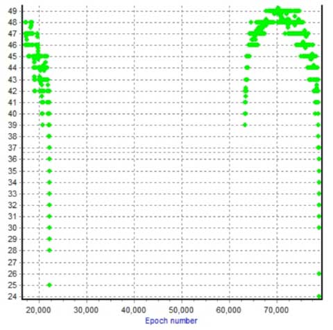
GPS Shows Large Position Shifts Due to Japanese Earthquake
 Simon Banville, a Ph.D. student working with Prof. Richard Langley at the University of New Brunswick, has analyzed the high-rate 1-Hz data from two stations of the International GNSS Service affected by the Sendai earthquake: MIZU at Mizusawa and USUD at the Usuda Deep Space Tracking Station. His analysis approach uses PPP or precise point positioning, a technique that requires meticulous modeling of all of the phenomena affecting GPS measurements to reveal station displacements with precisions approaching a few centimetres. Inputs include high-precision satellite orbits and clocks, which, in this case, were provided in the form of the "ultra-rapid products" generated at Natural Resources Canada and graciously provided by Yves Mireault. The displacements shown in the plots in terms of latitude, east longitude, and height are with respect to the station coordinates before the occurrence of the earthquake.
The MIZU ground motion plots show the station moving about 3.4 metres (11.2 feet) ESE in the first minute of the earthquake, and then recovering back to a final position about 2.4 metres (7.7 feet) ESE from the pre-earthquake location, during the following two minutes. As late as 2 minutes after the first shock, waves with amplitudes (peak-to-peak) of up to 0.25 metres (10 inches) and a period of 5-10 seconds can be seen.
Click on the thumbnail to view the displacement plots.
Yun Zhang Recognized at Celebration
 Dr. Yun Zhang, a Geodesy and Geomatics Engineering professor and Canada Research Chair in Advanced Geomatics Image Processing, was honoured at a recent celebration of UNB's research strengths. Vice-President (Research) Gregory Kealey hosted a reception on 18 February to honour three recent Canada Research Chair (CRC) appointments and the leaders of ten Canada Foundation for Innovation research infrastructure grants.
Dr. Zhang was presented with a framed letter from Prime Minister Stephen Harper congratulating him on his appointment to a CRC. “This recognition from your peers is a symbol of the importance of your research for the future of our country and its citizens, and is a testament to the high standards that you have achieved with your work,” the letter reads in part.
Dr. Zhang and his research group have developed many innovative technologies in the field of image processing for geomatics and have licensed the research results to several internationally leading imaging and mapping companies.
Click on the thumbnail image to view the letter and some photos taken during the ceremony.
John Hughes Clarke Awarded the Michael J. Keen Medal
 The Marine Geosciences Division of the Geological Association of Canada has awarded its Michael J. Keen Medal for 2010 to the University of New Brunswick's Dr. John Hughes Clarke. The medal is awarded annually to a scientist who has made a significant contribution to the field of marine or lacustrine geoscience.
Dr. Hughes Clarke is a professor and the Chair in Ocean Mapping in the Department of Geodesy and Geomatics Engineering at UNB in Fredericton, New Brunswick. “Dr. Hughes Clarke is an outstanding leader in marine geology and oceanography and is recognized by his peers and students. His scientific competence, enthusiasm, imagination and innovation mark Dr. Hughes Clarke as an extraordinary researcher in the field of ocean mapping,” said Dr. Brian Todd, a researcher at the Geological Survey of Canada.
In his nomination letter, Dr. Todd further said “Dr. Hughes Clarke participates in cutting-edge marine research in Canada and around the world. One of the highlights of his work during the past five years has been his sea floor mapping in Canadian Arctic waters, and in the Northwest Passage in particular. … Dr. John Hughes Clarke is one of Canada's leading marine geoscientists; he is a superb scientific leader and collaborator who sets an example for his colleagues and students.”
This is the second time the Michael J. Keen medal has been awarded to a GGE professor. The 1998 medal was presented to Dr. Larry Mayer, the first holder of the Chair in Ocean Mapping at UNB.
The Michael J. Keen medal honours the life and work of Michael John Keen (1935–1991), an award-winning Canadian geoscientist. From 1961 to 1977, he was a professor at Dalhousie University in the Department of Geology. He chaired the department for several years. From 1977 to 1991, he was with the Geological Survey of Canada's Atlantic Geoscience Centre in Dartmouth, Nova Scotia.
Yun Zhang Presents Breakthrough Technologies for Image Processing
 On January 24, Yun Zhang presented an invited seminar at MacDonald, Dettwiler and Associates Ltd. (MDA) in Richmond, British Columbia, on new techniques for optical and radar image processing.
Dr. Zhang introduced breakthrough algorithms and software tools developed by his research group–the Canada Research Chair Laboratory in Advanced Geomatics Image Processing, part of the Department of Geodesy and Geomatics Engineering at the University of New Brunswick.
He discussed a variety of techniques including UNB PanSharp, adjustable radar and optical image fusion, target moving information extraction from single sets of satellite imagery such as QuickBird and GeoEye-1, automated image matching of forest areas, generic sensor modeling based on rational polynomial coefficients, and automated digital elevation model reconstruction using interferometric synthetic aperture radar (InSAR).
Some of the techniques have already been used successfully by the imaging and mapping industry, while others are just ready for industry implementation.
MDA is a world-leading Canadian aerospace and information services company, and a significant player in the imaging and mapping industry.
GGE Members Featured in First Issue of New Geodesy Journal
![]() The first issue of the Journal of Geodetic Science includes a paper authored by Ph.D. student Robbie Kingdon and Professor Emeritus Petr Vaníček. The paper, entitled “Poisson Downward Continuation Solution by the Jacobi Method,” describes some work done to help solve an ongoing problem in geodesy and geophysics. As the authors put it, “A continuous plague in geodesy and geophysics is the problem of downward continuation of gravity. That is, the determination of the values of the field below the surface of the Earth from observations of gravity field on the surface.”
The first issue of the Journal of Geodetic Science includes a paper authored by Ph.D. student Robbie Kingdon and Professor Emeritus Petr Vaníček. The paper, entitled “Poisson Downward Continuation Solution by the Jacobi Method,” describes some work done to help solve an ongoing problem in geodesy and geophysics. As the authors put it, “A continuous plague in geodesy and geophysics is the problem of downward continuation of gravity. That is, the determination of the values of the field below the surface of the Earth from observations of gravity field on the surface.”
Among other applications, better procedures for the downward continuation of gravity will improve determinations of the geoid, the equipotential surface of the gravity field that is used a reference surface for heights and which is approximated by mean sea level.
The journal's first issue also includes an article by Prof. Em. Helmut Moritz, the distinguished Austrian geodesist, reviewing the current theoretical understanding and practical determination of the geoid.
The Journal of Geodetic Science is published by Versita, a leading central European science publisher, headquartered in Warsaw, Poland. Prof. Vaníček and Prof. Richard Langley serve on the journal's editorial advisory board.
William Brydone Jack, UNB's First Teacher of Surveying, Honoured
 A ceremony to celebrate the legacy of William Brydone Jack, the first professor to teach surveying at UNB and its predecessor, King's College, was held on January 13 in the Stewart Room of the Harriet Irving Library in Fredericton.
As part of UNB's 225th anniversary celebrations, the event included remarks by UNB President Eddy Campbell; Richard Langley, professor of geodesy and geomatics engineering; and William Ward, professor and chair of physics. A plaque marking the recent naming of asteroid Brydonejack, in honour of Brydone Jack, was unveiled by retired UNB physics professor, Merrill Edwards, and alumnus Don Kelly, past president of the William Brydone Jack Branch of the Royal Astronomical Society of Canada. The plaque will be mounted in UNB's Brydone Jack Observatory.
In his remarks, Dr. Langley said “I think it is safe to say that the Department of Geodesy and Geomatics Engineering at UNB owes its existence in no small part to William Brydone Jack.” Brydone Jack gave lectures on surveying as part of the mathematics curriculum and helped to establish special courses in civil engineering and surveying.
Dr. Langley's full remarks and his presentation “From Stars and Steeples to Software and Satellites: William Brydone Jack's Legacy to Surveying and Mapping” are available on UNB's 225th anniversary website.
The Department of Geodesy and Geomatics Engineering has helped celebrate other anniversaries associated with Brydone Jack including his arrival at King's College in 1840 and the establishment of a stone pillar on the observatory's meridian in 1874 (photo).