

2019 ·
2018 ·
2017 ·
2016 ·
2015 ·
2014 ·
2013 ·
2012 ·
2011 ·
2010 ·
2009 ·
2008 ·
2007
2006 ·
2005 ·
2004 ·
2003 ·
2002 ·
2001 ·
2000 ·
1999 ·
1998 ·
1997 ·
1996 ·
1995
 · What is RSS?
GGE News - 1999
- Ng'ang'a and Rakai Winners of 1999 CPS Scholarships
- Oromocto High School Presented with Topographic Map
- Financial Support from ANBLS
- Fall 1999 Student Paper Competition
- Satellite Aircraft Navigation Closer to Reality Thanks to GGE
- Sue Nichols Visits Kazakstan Again
- Over the Bounding Waves with Hydro Camp 1999
- Recent Arrivals in the Department
- Kudos for Department Faculty
- Visitors to the Department
- Recent Departures from the Department
- Larry Mayer Awarded Honorary Doctorate
- A.W. McLaughlin Scholarship Donation
- Y. C. Lee Receives President's Award for Achievement from Hong Kong Polytechnic University
- Ever Wonder What a Ceratolithus larrymayeri is?
- Nguyen and Bisnath Geomatics Canada Scholarship Winners
- 1999 Edition of Angus Hamilton Lecture Series
- Vaníček's Last Lecture
- Spring Student Technical Conference
- Chrzanowski Awarded Honorary Professorship
- Professors Emeriti Help to Launch New Book
- Dave Monahan Inaugurates Law of the Sea Seminar Series
- GGE Featured in Maclean's University Guide
- McLaughlin Recipient of CCLS Champlain Award
- Coleman Heads CFI GEOPLUS Network Project
Ng'ang'a and Rakai Winners of 1999 CPS Scholarships
 In December 1999, Samson Ng'ang'a and Mele Rakai each received a $5,000 scholarship from the Centre for Property Studies. These scholarships, provided by funding from the Canadian International Development Agency (CIDA), are to help students from developing countries obtain a graduate level education in property studies. UNB's Centre for Property Studies (CPS), inaugurated in June 1997, is premised on the central importance of property to economic, social, and political development, and to environmental sustainability.
Sam Ng'ang'a, from Nairobi, Kenya, is currently working toward his Master of Engineering (M.Eng.) degree in land information systems and land information management under the supervision of John McLaughlin. He joined the Department in the fall of 1998 after working as a field engineer with Doctors Without Borders (Médecins sans Frontières (MSF)) and the United Nations High Commissioner for Refugees (UNHCR) in the Dadaab refugee camp located in the North Eastern province of Kenya. Sam has an undergraduate degree in surveying from the University of Nairobi (UON). He has also worked with several surveying companies in Kenya and maintains close ties with UON. Sam is currently the Director of Socials for the African Student Union at UNB.
Mele Rakai, originally from "the beautiful village of Sawana on the island of Vanua Balavu, in Fiji's eastern province of Lau," now calls Suva, Fiji's capital, home. Mele is currently a Ph.D. candidate in land administration under the supervision of Sue Nichols. Mele graduated with a BSurv from Otago University in 1983 and an MSurvSc from Melbourne University in 1993. She worked on developing the Fiji Land Information System between 1994 and 1995, and at the University of the South Pacific in 1996 before coming to UNB in 1997. In 1994, she won the FIG prize for the best young surveyor's paper at the international conference in Melbourne. Mele is here with her 9 year old son, who keeps her busy during any spare minutes.
Our congratulations to both Sam and Mele.
Read the associated UNB news release.
Oromocto High School Presented with Topographic Map
 In June 1999, we reported that Oromocto High School had joined the list of schools that our second year students had surveyed. At that time, copies of the paper topographic map were sent to a local framing company to be made into products that could be displayed both on the walls of our department and those of the high school.
The map was formally presented to the high school at a special ceremony on 21 December 1999. The current principal, Dr. Sharon Crabb, the past principal, Paul Dowling, and teacher Calvin MacDonald gratefully accepted the plan on behalf of the OHS faculty and students. Beth-Anne Martin, one of the OHS students who participated in the project, plans on enrolling in geomatics engineering at UNB in September 2000.
Click on the thumbnail image to get a better look at the presentation, 27 KB.
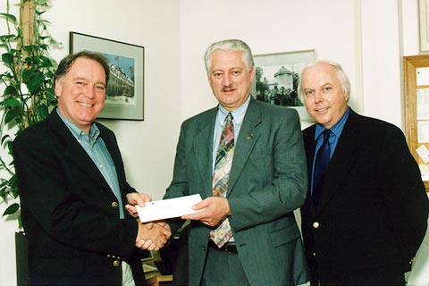
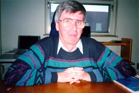
Financial Support from ANBLS
 Steven Hartley, the Executive Director of the Association of New Brunswick Land Surveyors, presented a cheque from the Association of New Brunswick Land Surveyors (ANBLS) for $1,500.00 to Sue Nichols to support the land administration program at UNB. The funds will be used to purchase new multimedia presentation software and a scanner for use in the revised land administration curriculum and to update various library and computer resources. Thanks ANBLS! (Photo: S. Nichols' camera, 7 December 1999)
Click on the thumbnail image to get a better look, 20 KB.
Fall 1999 Student Paper Competition
 The New Brunswick Branch of the Canadian Institute of Geomatics (CIG) held its semi-annual student paper competition on Tuesday, 7 December 1999, in the new David Wells Multimedia Room (E-11 Head Hall). Four participants had been selected from the excellent senior student presentations the week before. The winner this year was Jeremy Nicholson for his presentation on "Preparation of Side Scan Targets for Databases." Jeremy described how a data set for Sidney Harbour, Australia, was processed using CARIS to prepare databases for marine wrecks and other subsurface objects.
Click on the thumbnail image to get a better look at the participants, 28 KB.
Satellite Aircraft Navigation Closer to Reality Thanks to GGE
"Aviation authorities around the world are collaborating on the development and adoption of satellite navigation," says Richard Langley of UNB's department of geodesy and geomatics engineering.
Sue Nichols Visits Kazakstan Again
 In November 1999, Sue Nichols travelled to Kazakstan as part of the World Bank project there to develop a training and education program for land administrators.
Click on the thumbnail image to look at pictures taken during the trip, 56 KB.
Over the Bounding Waves with Hydro Camp 1999
 Over the "weekend" of 3 to 7 November 1999 (we believe in extended weekends at UNB), 19 UNB GGE students had the opportunity to gain practical experience with modern hydrographic equipment and software. These skills complemented the theoretical understanding provided by their coursework in UNB's Hydro I and Hydro II courses.
The UNB students were joined in St Andrews, New Brunswick, by eight programrs and customer service employees from Universal Systems Limited (many of whom saw in operation for the first time the multibeam systems for which they write and service processing software). Added to these were two employees of Fugro Jacques Geosciences (FJG) (who were able to pick the brains of the USL employees to find answers to some questions they have had about processing multibeam data). Most of the legwork in organizing the weekend was carried out by Jeremy Nicholson, who is both a UNB student (expecting to graduate Christmas 1999), and a USL employee.
The students conducted a series of multibeam sonar surveys and data cleaning exercises. For this they used a Reson 8101 multibeam system provided by FJG; a DMS-05 vessel motion centre provided by TSS UK and Romor Equipment of Dartmouth, N.S.; an SG Brown gyrocompass rented from an agency in Houston, Texas; and a sound speed profiler lent by the Canadian Hydrographic Service. Additionally, the students had access to seven Windows NT workstations equipped with USL's CARIS HIPS and SIPS software, the facilities of UNB's vessel Mary O, the Huntsman Marine Science Centre, and the Department of Fisheries and Ocean's (DFO) St Andrews Biology Station.
Click on the thumbnail image to look at pictures taken during the camp, 173 KB.
Recent Arrivals in the Department
David Fraser joined the department in July 1999 as a one-year replacement for Marta Wojnarowska, who is on a leave of absence. David comes to us from Geomatics Canada where he had spent the last three years as a project engineer. He will be responsible for managing the day-to-day operations and equipment contained in our GIS lab.
Michael Weber joins the Ocean Mapping Group from the Department of Geology, University of Cologne, Germany. Dr. Weber, who holds a Postdoctoral Fellowship, is doing research under the supervision of Larry Mayer. Michael will be with us until June 2001.
Jing (Jerry) Zhang took over as Ocean Mapping Group's Computer System Manager in August. He has an appointment until September 2000.
Kudos for Department Faculty
Petr Vaníček also retired in July 1999. Named Honorary Research Professor until June 2002, Petr is still active in research with a number of graduate students under his supervision and visiting scholars to look after. Petr can be reached at all his former addresses, as he is still very much an active member of the department.
The department held a retirement party for Wolfgang and Petr at the Mactaquac Lodge, just outside Fredericton.
James Secord was named Acting Assistant Dean of Engineering this year. He will hold that position until June 2000. James now spends part of each day out of our department and in what he refers to as the "Deanery."
Visitors to the Department
We have two short-term visitors from "down under". Dr. Peter Zwart from the University of Tasmania, Australia, will be with us until December 1999. He is working with the Centre for Property Studies on a project the goal of which is to enhance civic decision making within a virtual community. Dr. Chris Hoogsteden from the University of Otago in New Zealand will spend two months working with the Centre for Property Studies and Service New Brunswick (SNB). He is examining the demand and usage patterns of Service New Brunswick customers, especially since SNB introduced its WWW-based browser services.
Another short-term visitor is Bart Peeters from the Department of Aerospace Engineering at the Technical University of Delft. Bart will be working with Prof. Langley's group on accuracy analysis of GPS satellite ephemeris corrections supplied by the Wide Area Augmentation System.
Recent Departures from the Department
Tianhang Hou, a research assistant with the Ocean Mapping Group, moved to New Hampshire in August 1999. Tian originally joined Larry Mayer's team in July 1992, and eventually became a part-time graduate student working toward his Ph.D. in ocean mapping. Tian is now at the University of New Hampshire, and he can be reached at thou@cisunix.unh.edu.
Martin Leese, Computer Systems Manager for the Ocean Mapping Group, decided to go for his Ph.D. in California. Martin joined the OMG in August 1994 and departed in August 1999 for what are supposed to be warmer climes (although after our HOT summer, Martin may be in for a disappointment in that department). We wish Martin good luck with his studies at Stanford University. He can be reached at mleese@leland.stanford.edu.
Larry Mayer Awarded Honorary Doctorate
The actual award was made up of a number of elements. There was the diploma pictured here, a gold ring with raised laurel leaves, and the crowning glory - an actual live laurel leaf "crown". This crown of laurel leaves originated in classical mythology, where it was associated with Apollo. It became the only prize awarded at the Olympic Games, and was the symbol of victory in triumphal processions of the Roman Empire. During the Middle Ages, the crown came to represent the poet and to indicate wisdom. This latter attribute moved the wreath to academia, where it is used in the ceremony conferring the degree of Doctor of Philosophy. The doctoral ring symbolizes the loyalty of the individual receiving the degree to his discipline. Finally there was the fanfare. As the laurel crown encircled Larry's head, a cannon boomed in the distance, and later in the day Larry was given the cartridge casing as a souvenir.
We are very proud of Larry and his achievements.
Click on the thumbnail image to look at photos taken during the ceremony and the diploma, 334 KB.
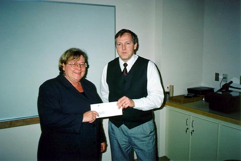
A.W. McLaughlin Scholarship Donation
 The Association of New Brunswick Land Surveyors donated $2,000 to the A. W. McLaughlin Entrance Scholarship in Surveying Engineering on 2 September 1999. The scholarship is open to full-time students entering our program. In the picture, Dave Coleman, department chair, is accepting the envelope, Doug Morgan, president of the ANBLS, is proffering the money, and John McLaughlin, in this case Archie McLaughlin's son (and otherwise known as Vice President Research and International Cooperation) is looking on. We certainly appreciate the interest the ANBLS consistently shows in our department. (Photo: Joy Cummings, 2 September 1999)
Click on the thumbnail image to get a better look, 29 KB.
Y. C. Lee Receives President's Award for Achievement
from Hong Kong Polytechnic University
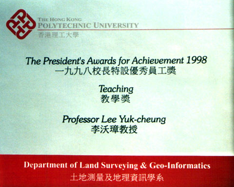 Y. C. Lee was presented with the President’s Award for Achievement from Hong Kong Polytechnic University in May 1999. Y.C. has been on leave from UNB since September 1995 when he joined the faculty of the Polytechnic. The President’s Awards were introduced in 1996 as a means of giving recognition to those colleagues who achieved outstanding performances and/or made distinguished contributions to their profession or field of work. Y.C. won the award for the excellent quality of his teaching, for his enthusiasm with and care of his students, and for his teaching philosophy which encourages students in the active pursuit of knowledge.
We offer him congratulations and are looking forward to having Y.C. and his family back in Fredericton on a permanent basis come the end of August 1999.
Click on the thumbnail image to get a better look at the award, 46 KB.
Ever Wonder What a Ceratolithus larrymayeri is?
 A Ceratolithus larrymayeri is a newly discovered Ceratolith named in honour of our Larry Mayer. Ceratolithus larrymayeri is "a delicate, morphologically unusual ceratolith built of three thin elements (horns or spines) with featureless surface" [Raffi et al., 1998, p. 39]. Mind you, this Ceratolith (a nannofossil) is only about 25-30 µm, with a maximum length to the horns of about 20 µm. Not something that you would take home as a pet. Congratulations to Larry for being immortalized so young.
Click on the thumbnail image to get a better look at Larry's namesake, 29 KB.
Source of quotation and graphics:
Raffi, I., J. Backman, and D. Rio (1998). Evolutionary trends of tropical calcareous nannofossils in the late Neogene. Marine Micropaleontology, Vol. 35, pp. 17-41.
Nguyen and Bisnath Geomatics Canada Scholarship Winners
 Huong Thi Thu Nguyen and Sunil Balkaran Bisnath have been awarded Geomatics Canada Scholarships for 1999. The Geomatics Canada Scholarship Program is funded by Geomatics Canada, of Natural Resources Canada, and administered by the Canadian Institute of Geomatics. Nine university and nine college/technical institute scholarships are awarded each year. Of the nine university scholarships awarded across Canada, two were won by UNB GGE students.
Huong is a fourth year, Bachelor of Science in Engineering (Geomatics) student. Sunil is a Ph.D. candidate working under the supervision of Dr. Richard Langley. Both Huong and Sunil will receive their $1,500 awards from the minister of natural resources, the Honourable Ralph Goodale. The awards will be presented during the usual UNB awards ceremony in October or November 1999.
1999 Edition of Angus Hamilton Lecture Series
 On the evening of 14 April, the 1999 Angus Hamilton Lecture was held in the Dineen Auditorium in Head Hall. Sponsored by the Champlain Institute, Service New Brunswick, the Canadian Institute of Geomatics, the Maritime Geomatics Committee, and the University of New Brunswick, the Series was established to bring influential guest speakers from around the world to the Maritimes to give two presentations, one in Fredericton and the other in Halifax.
This year, the speaker was Roger Longhorn, an independent IT consultant, working since 1992 as an expert in geographic information policy issues for the European Commission's DG XIII/E in Luxembourg on the IMPACT and INFO2000 information market programs. Mr. Longhorn brought to the audience an overview of what is happening in the European geomatics sector.
Click on the thumbnail image to look at scenes from the event, 52 KB.
Vaníček's Last Lecture
 On Monday, 12 April 1999, Petr Vaníček gave his last lecture - he retires on 30 June 1999. Noted for requiring a high level of understanding of geodesy and adjustment theory in the students, Petr's courses had a certain reputation. Many students have breathed a collective sigh of relief now that Petr's teaching career has come to a close.
Click on the thumbnail image to look at scenes from the event, 73 KB.
Spring Student Technical Conference
 The spring student technical conference was held in the Dineen Auditorium of the engineering building on the afternoon of 7 April 1999. Fourteen graduate and undergraduate students made presentations covering a variety of topics such as GPS, hydrography, GIS, geodesy, and LIM. Organized by Mele Rakai and Rima Ammouri, with organizational assistance from Linda O'Brien, and technical assistance from Howard Biggar, the full schedule ran well into the evening.
Click on the thumbnail image to get a better look at some of the participants, 37 KB.
Chrzanowski Awarded Honorary Professorship
 On 18 and 19 March 1999, Prof. Dr. Richard Gorecki (President) and Prof. Dr. Vlodimir Baran (Dean, Geodesy and Regional Planning), both from the Olsztyn University of Agriculture and Technology, Poland, visited the department. Their visit served two purposes. The more significant purpose was to present to Adam Chrzanowski an honorary professorship from the Faculty of Geodesy and Regional Planning of the Olsztyn University of Agriculture and Technology. The second purpose was to renew a research partnership agreement with the university. Congratulations to Adam on both occurrences.
Click on the thumbnail image to look at scenes from the event, 102 KB.
Professors Emeriti Help to Launch New Book
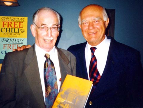 On 10 March 1999, professors emeriti Angus Hamilton (on the left in the photo) and Adam Chrzanowski (on the right), helped to launch Mapping a Northern Land: The Survey of Canada, 1947-1994. The book launch, hosted by The Canadian Institute of Geomatics, Fredericton Branch, celebrated two chapters written by Angus and Adam. Angus wrote Chapter 13, Education, and Adam wrote Chapter 16, Engineering and Mining Surveys. Department members figure prominently in these and other chapters in the book. Published by McGill-Queens's University Press and edited by Gerald McGrath and Louis Sebert, the book reveals the history of surveying and mapping in Canada since the Second World War.
The book is also available from McGill-Queen's University Press and Chapters.
Click on the thumbnail image to get a better look at the authors, 28 KB. (Photo: Wayne Walsh, 10 March 1999)
Dave Monahan Inaugurates Law of the Sea Seminar Series
 On Wednesday, 10 March 1999, Dave Monahan moderated the first session in a series of seminars at UNB on the United Nations Law of the Sea. Monahan, Director of Marine Geomatics with the Canadian Hydrographic Service, is spending a year with us, working with Department members to establish the Canadian approach to claiming the continental shelf under the U.N. Law of the Sea. He is also taking graduate courses towards an M.Sc.E. degree in ocean mapping.
Why is this seminar series important? All major industrialised nations have ratified the United Nations Convention on the Law of the Sea (UNCLOS), with the exception of the United States and Canada. With the U.S. now expected to ratify by August 1999, we can expect that this issue will come under intense scrutiny in Canada. We are fortunate to have at UNB, and in the surrounding communities, a unique collection of expertise that may be very useful in helping Canada define its position on this critical issue. The objective of the seminar series is to bring together university colleagues from a range of relevant disciplines (Ocean Mapping, Law, Geology, Geodesy, Geophysics, History, Political Science, Economics, and others), together with members of industry and government. The format is a short presentation leading to open discussion.
The first session focused on the Statement of the Problem. This consisted of a brief look at the treaty, its contents, what other countries are doing in preparation, resource assessment, claiming the continental shelf, boundaries between states, opportunities for Canadian companies and possibilities for Canadian universities to provide education and training. Within this framework, there was a discussion of future topics to be addressed.
For more information, consult the Law of the Sea web site.
Click on the thumbnail image to get a better look at our distinguished visitor, 22 KB. (Photo: Wendy Wells, 17 February 1999)
GGE Featured in Maclean's University Guide
McLaughlin Recipient of CCLS Champlain Award
 In January 1999, John McLaughlin received the Canadian Council of Land Surveyors' (CCLS) Champlain Award. This award, established in 1986, is, as stated in the CCLS Handbook, "a means to recognize achievements and efforts both past and present, by and for the profession of land surveying."
Fredericton members of the CCLS, the Association of New Brunswick Land Surveyors, and the Canadian Institute of Geomatics gathered for a luncheon presentation in the Governor's Dining Room at the Lord Beaverbrook Hotel.
Angus Hamilton, Professor Emeritus in the Department, is a former recipient of the award. He was recognized in 1987 for his contributions to the profession of land surveying.
Click on the thumbnail image to get a better look at the award, 69 KB.
Coleman Heads CFI GEOPLUS Network Project
 The Canada Foundation for Innovation (CFI) and the Atlantic Canada Opportunities Agency (ACOA) recently awarded UNB a two-year research development infrastructure grant totalling $315,500. David Coleman is the project leader, bringing together faculty, staff, and students not only from Geodesy and Geomatics Engineering, but also from Forestry and Environmental Management, and Law. The project is entitled the GEOPLUS Network: Infrastructure for Geomatics, Resource Management and Property-Related Research. Its aim is to bring together in one easily accessible area geomatics- and property-related information technologies that are used across UNB as tools to support discipline-specific applications and research projects.
Over the years, as new expertise and technology evolved, two problems developed. One was a duplication of hardware and software, and the other was a confusing and costly array of independently negotiated licenses and maintenance agreements. The CFI funding will support development of a campus-wide spatial and property information infrastructure through the purchase of new computer hardware, software, and specialized data collection equipment. In particular, it will streamline the management of relevant software, framework datasets, and on-line document resources across the campus. This will provide all campus researchers with access to the same level of service and information. It should also provide the opportunity to develop at UNB a world class institution for cooperative and multi-disciplinary research related to the integrated administration and informed management of land- and property-related resources.
Read the associated UNB news release.