

Mapping Beneath the Reversing Falls
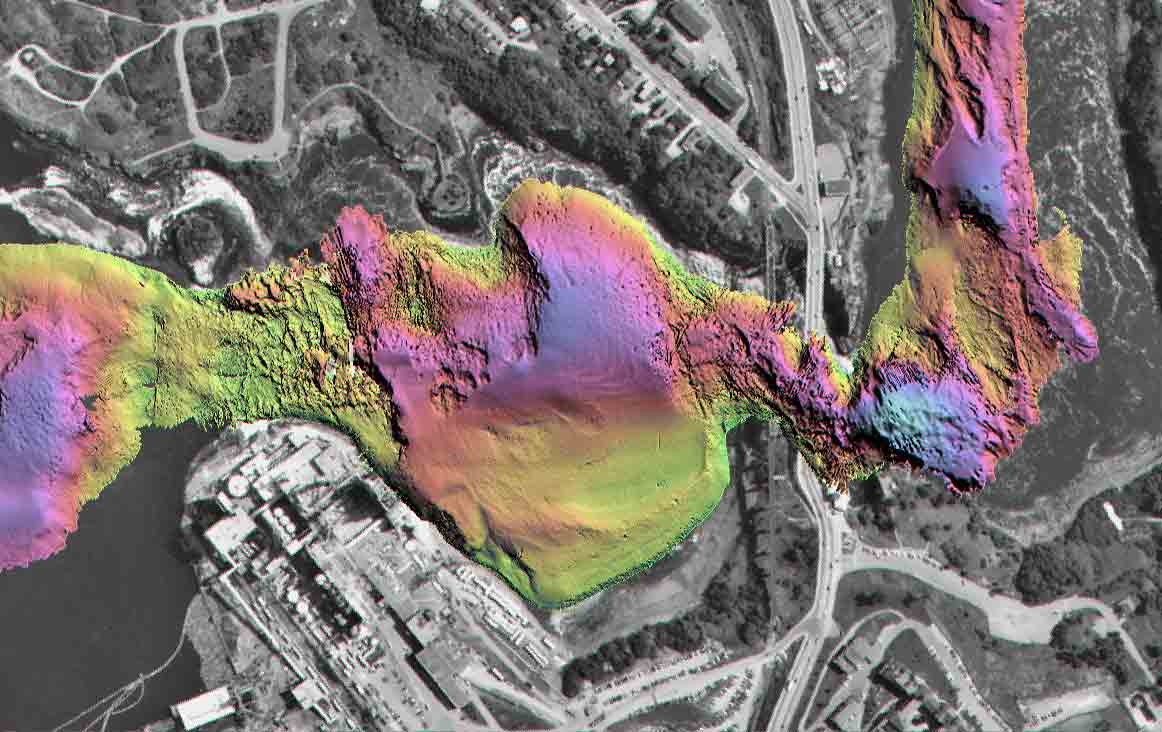
This image shows an underwater survey of the most turbulent part of the falls. It was done using a Canadian Hydrographic Service (CHS) survey launch equipped with a multibeam sonar system. What makes this survey particularly unique is the use of a differential GPS (DGPS)-aided inertial navigation system (INS). The package consists of an inertial measurement unit integrated with two 12-channel GPS cards. The two-antenna solutions are used only as long-period control on the horizontal position and azimuth of the vessel. The output navigation (provided at 100 Hz) is an inertial navigation solution aided by the DGPS.
The big complication in transiting the Reversing Falls is the extreme bounding topography and the presence of two closely spaced bridges that serve to mask satellites at precisely the most critical point. The aided INS solution, however, is insensitive to short-period (less than one minute) GPS outages. The INS effectively acts as a flywheel during loss of (or erroneous) GPS solutions. This occurred repeatedly for periods of several tens of seconds each time the survey launch passed under the falls bridges or close to the steep shore.
For the first time, through the use of combined inertial and GPS technologies, the CHS was able to produce truly accurate maps of this critical navigational channel. These will be used to allow larger vessels, which previously would not consider the transit, to enter the St. John River.
The project coordinators were John E. Hughes Clarke and Marcelo Santos of the Department of Geodesy and Geomatics Engineering. The boat driver, whose expertise made the project possible, was Carmen Reid, Canadian Hydrographic Service (CHS), Bedford Institute of Oceanography, Dartmouth, Nova Scotia.
The Canadian Hydrographic Service braved the treacherous waters of the Reversing Falls in a survey launch equipped with a Kongsberg Simrad (Horten, Norway) EM3000S multibeam sonar and the Applanix (Richmond Hill, Ontario) POS/MV 320, consisting of an inertial measurement unit integrated with two NovAtel (Calgary, Alberta) 3151R narrow correlator, 12-channel, 10 Hz output OEM GPS cards.
The project received an honorable mention in GPS World's Applications Contest VIII.