

Update of Swissair Flight 111 Story
Dr. John Hughes Clarke
UNB Ocean Mapping Group
The SwissAir seabed search data are no longer restricted. We can, therefore, provide you with a sample image. The image is of the seabed south of Peggy's Cove, Nova Scotia, in the region of (but not including) the crash site of SwissAir Flight 111.
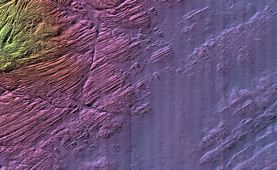
The image is a plan view of the seabed that is 3600 m across. It is a small subset of the total multibeam bathymetry survey performed around the crash site. The depths range from approximately 30 m to 60 m (yellows to purples). The image resolution is 4 m (downgraded from the 1 m version used at sea) to show the regional geology rather than the details.
The image shows the range of seabed types in the region. As can be seen, there is an extensive bedrock outcrop in the area. The rock types are ancient sedimentary rocks called the Meguma Terrane which, for example, outcrops in Point Pleasant Park in Halifax, N.S., but is not the granite that one sees outcropping at Peggy's Cove. The whole area is partially overlain by glacial sediments including till deposits and glacial erratics (randomly distributed boulders up to 5 m in size).
This survey was performed by the Canadian Hydrographic Survey (CHS) (part of Fisheries and Oceans Canada) based at the Bedford Institute of Oceanography (BIO) in Dartmouth, N.S. The CHS used the survey launch CSL Plover (10 m long) deployed from the CCGS Mathew (70 m long), a hydrographic survey vessel based at BIO, which maps the Atlantic Ocean region (mainly around Newfoundland and Labrador).
The role of the UNB Ocean Mapping Group (OMG) was to provide the most rapid processing and visualisation of the multibeam data (this is what we specialise in). The OMG was requested by the CHS to help, and OMG personnel were on board the vessel 18 hours after it sailed. All the multibeam survey data (approximately 600 depths a second for a total of approximately 100 hours of continuous acquisition, which resulted in a collection of about 200 million soundings) was processed by OMG staff (John Hughes Clarke, Larry Mayer, and Edouard Kammerer) on board the vessel. This fast processing allowed us to supply these sorts of maps, within a few hours of acquisition, to the rest of the fleet for seabed search and salvage operations. Normal processing time for a survey data set of this magnitude is several months.
The multibeam sonar used was a Simrad EM3000 that is capable of finding objects of about 2 m diameter or greater in these water depths. As an example, an intact MD11 aircraft is about 61 m long and has a fuselage diameter of about 6 m. The sonar was capable of identifying suspicious objects on the seafloor that might be part of the wreckage. As you can see from the image, one of the biggest problems was the fact that there were so many natural targets. By comparison, the TWA 800 crash site surveys took place in a generally naturally-featureless area making it easier to find targets.
This sort of an image is fully geographically registered and was put directly into electronic chart software that allowed the other vessels (sidescan, ROV (remotely-operated vehicle), dragger, salvage, and diver support platforms) to navigate their survey instruments as accurately as possible to the site of suspected anomalies.
About the image: The data are the property of the Transportation Safety Board of Canada; the data were collected by the Canadian Hydrographic Service, in collaboration with the Canadian Coast Guard, the Canadian Navy, Geological Survey of Canada, Royal Canadian Mounted Police, and the U.S. Navy; and was processed by the Ocean Mapping Group.