|
An Assessment of Current and Potential Fragmentation of Forest Ecosystems
in the Fundy Model Forest
Matt Betts, GFERG
Ron Taylor, Fundy Model Forest (email: ron@fundymodelforest.net)
"Degree of forest fragmentation or connected ness of forest ecosystem
components" is one of the principal indicators of forest biodiversity
in the Fundy Model Forest (Etheridge et al. 1999). However, very little
information exists on the rate of habitat fragmentation in the FMF.
The GFERG has examined a range of methodologies that have been used
to measure fragmentation. The purpose of this proposed study is to apply
one or more of these methodologies to the Fundy Model Forest. This will
provide managers with quantified baseline data to assist in long-term
forest management decision-making. The project has three major phases:
(1) Identify and research species which will be good indicators of fragmentation,
(2) Use a method defined by the GFERG to measure the rate and extent
of fragmentation as it relates to these indicator species. (3) Propose
an approach for integrated landscape-level planning in the Fundy Model
Forest.
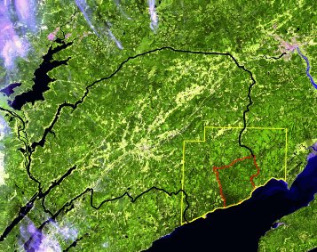
Current satellite image of the Greater Fundy Ecosystem (yellow boundary),
Fundy National Park (red boundary) and the Fundy Model Forest (black
boundary). Satellite images are being used to update the 1993 Geographic
Information System (GIS) so that the current state of fragmentation
can be assessed.
Click
to Return to the Main Page
|